Castle Point
The following sites have been selected to represent the different aspects of geology and landscape in the district. Not all sites have something to see; many are solely of historical interest as a record of an important or interesting discovery.
Some sites are not strictly geological but have a geological connection. Geological sites are therefore defined in their widest sense and include, for example, buildings, walls, wells, spas, springs, graves, boreholes, plaques, landslips and viewpoints.
Important note:
Not all of the sites here described are accessible. Some sites are on private land and can only be viewed from footpaths that pass through or alongside the site. Inclusion of a site on this list does not, therefore, imply any right of access. Please remember not to trespass on private land.
Sites of Special Scientific Interest (SSSIs)
No geological SSSIs have been notified in the district.
Local Geological Sites (LoGS)
Click the links below to read and download the district report and LoGS citations for Castle Point Borough Council
Castle Point Borough Council – Report on Local Geological Sites – November 2024
CptG1 – Coombe Wood
Steeply sloping woodland situated on the Claygate Beds with Bagshot Sand on the highest ground. The layers of sandy clay that make up the Claygate Beds can be seen in the sides of a stream that cuts through the wood in a very steep valley which is almost a ravine.
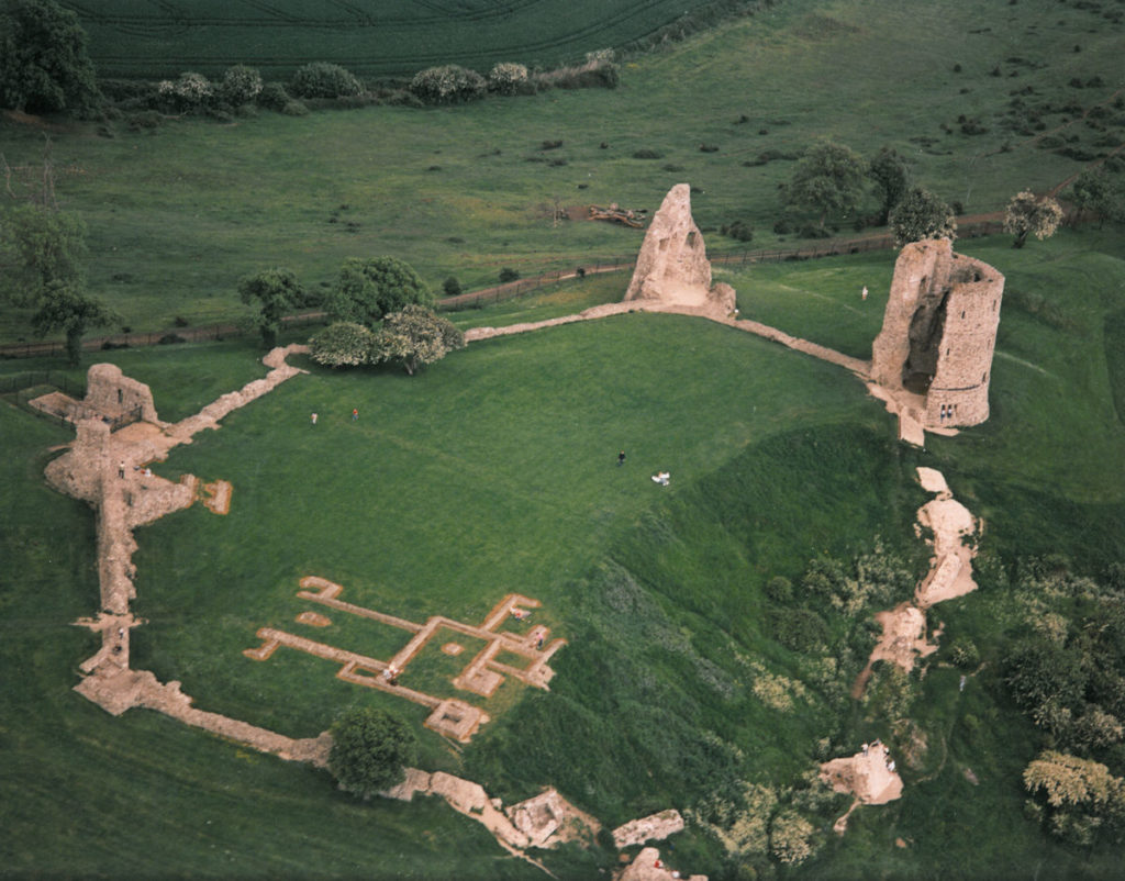
CptG2 – Hadleigh Castle Landslip
The most impressive London Clay landslip in Essex. The severe effects on the castle can be clearly seen.
CptG3 – Hadleigh Park
Fine undulating landscape of London Clay, overlain by Claygate Beds and Bagshot Sand. The exposure of Bagshot Sand created in 2007 has been obscured by the Olympic cycle track but a new exposure is planned. Site of British Geological Survey’s 1973 Hadleigh borehole. Fine views over Thames to Kent.
CptG4 – Pound Wood
Fine undulating landscape of London Clay, overlain by Claygate Beds and Bagshot Sand. Highest point capped with Daws Heath Gravel, which was laid down by the River Medway probably over a million years ago. No visible exposures of the underlying rocks but pebbles from the gravel are conspicuous in paths and roots of fallen trees.
CptG5 – Shipwrights Wood
Steep slopes of London Clay, Claygate Beds and Bagshot Sand with landslips. One of the best woodlands in Essex for natural landforms.
CptG6 – St. Peter’s Church Boulders
Two fine sarsen stones that were recorded here in the 1930s can still be seen today. One is under a hedge next to Church Road, on the north-east corner of St. Peters Church Hall and the other is now situated in the church porch for safekeeping but previously stood outside in the churchyard.
CptG7 – West Wood
West Wood has a varied geology and Prittle Brook flows in the valley in the centre of the wood which is underlain by a bedrock of Claygate Beds. To the north and south the rising ground gives way to the overlying Bagshot Sands. On the highest ground, close to the north and south boundaries of the wood, there are overgrown shallow pits where lots of exotic gravel can be found. This is Daws Heath Gravel which is an ancient remnant of a terrace of river gravel deposited by the River Medway when it flowed across eastern Essex in the early part of the Ice Age, perhaps as much as a million years ago.
The Rayleigh Hills
Research has shown that the River Medway in Kent is a very ancient river and before the diversion of the Thames to its present course the Medway flowed across eastern Essex to join the Thames in what is now north Essex or Suffolk. The route of this river has left behind evidence of its existence as layers and patches of gravel between Hadleigh and Bradwell-on-Sea. The higher the altitude of this gravel the older it is and the highest of this gravel (known as Daws Heath Gravel and Claydons Gravel) is on the Rayleigh Hills between Hadleigh and Hockley which, in places, is over 80 metres (240 feet) above sea level.
It is difficult to believe that this gravel, which caps some of the highest ground in south Essex, was originally the floor of an ancient river valley. However, this must have been the situation over 700,000 years ago. Like the gravel on the summit of the Langdon Hills (which was deposited by another northward-flowing tributary of the ancient Thames), the Rayleigh Hills gravel contains distinctive pebbles of chert from the Lower Greensand of The Weald, together with other rock types that could only have been deposited by a river flowing from the south. It also contains boulders of sarsen stone which must also have originated in Kent. An example is the 45 centimetre (18 inch) diameter specimen in the south wall of Hadleigh Church although nineteenth century observers have described much larger boulders that were formerly present on the roadside in several parts of the district.
The existence of this high level river gravel may even have contributed to the creation of the Rayleigh Hills by protecting the Bagshot Sands and Claygate Beds from erosion while the surrounding areas were slowly reduced to the present lowland. It is a vivid reminder of the immense erosion that has taken place during the ice age and how the land surface can be considerably reshaped in relatively short periods of geological time.