Epping Forest
The following sites have been selected to represent the different aspects of geology and landscape in the district. Not all sites have something to see; many are solely of historical interest as a record of an important or interesting discovery.
Some sites are not strictly geological but have a geological connection. Geological sites are therefore defined in their widest sense and include, for example, buildings, walls, wells, spas, springs, graves, boreholes, plaques, landslips and viewpoints.
This is not a complete list of geological sites in the district. Others will be added and descriptions expanded as further research is carried out.
Important note:
Not all of the sites here described are accessible. Some sites are on private land and can only be viewed from footpaths that pass through or alongside the site. Inclusion of a site on this list does not, therefore, imply any right of access. Please remember not to trespass on private land.
Sites of Special Scientific Interest (SSSIs)
No geological SSSIs have been notified in the district.
Local Geological Sites (LoGS)
Click the links below to read and download the report and citations for Epping Forest District Council.
Epping Forest District Council – Report on Local Geological Sites – August 2025
EpG1 – Beauchamp Roding Sarsen stone
Large sarsen stone in the churchyard of St. Botolph’s Church. It is close to the north-east corner of the church.
EpG2 – Blackweir Pond, Epping Forest
Blackweir Pond is a picturesque pond in Epping Forest that was originally a gravel pit. The origin of the gravel (Woodford Gravel) is a subject of scientific debate; as a deposit of a northward-flowing tributary of an early Thames that crossed central Essex at the time or, diametrically opposed, as southward-flowing outwash from the Anglian glacier. Thus, there is significant value in investigating the gravel further.
EpG4 – Copped Hall Green Sarsen Stone
A large sarsen stone near Lodge Farm at the junction of two farm tracks. Also known as the Upshire Stone.
EpG6 – Holyfield Puddingstone, Waltham Abbey
In the hamlet of Holyfield is a puddingstone boulder 90 cm long on the grass verge only a few yards from the main road and a short distance along Puck Lane. This is the boulder that started E.A. Rudge on his quest for evidence of an ancient conglomerate trackway across southern England.
EpG7 – Lords Bushes, Buckhurst Hill
The site lies on the western side of the Roding Valley, with Woodford Gravel in the higher western area, giving way downhill, eastwards, to London Clay, with downwash (head) obscuring the junction. The origin of the gravel (Woodford Gravel) is a subject of scientific debate; as a deposit of a northward-flowing tributary of an early Thames that crossed central Essex at the time or, diametrically opposed, as southward-flowing outwash from the Anglian glacier. Thus, there is significant value in investigating the gravel further.
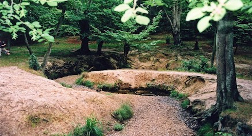
EpG8 – Loughton Brook Meanders
Meanders are a common feature of lowland rivers but usually they are large, making it difficult to appreciate them from ground level. Loughton Brook has a fine group of small-scale, slightly incised meanders which are easy to study and accessible to visitors. The precise reasons why a river adopts a meandering course are uncertain, but the sinuous curves may be the result of the balance between energy and friction when a low energy river moves fine sediments down a shallow gradient.
EpG9 – Oak Hill Pit, Theydon Bois
This former brickworks pit in Epping Forest forms a deep amphitheatre in the forest with a 7 metre high slope covered in beech trees. The pit dates back to at least 1884 and is historically important as well as providing a potential exposure of Claygate Beds. Although currently there are no exposures, the sandy clay and seams of sand are often visible in the roots of fallen trees and in heaps thrown out from animal burrows.
EpG10 – Shales More Tufa Springs, Stapleford Tawney
Tufa springs at the junction of London Clay and overlying Anglian till. Calcium salts in solution (derived from dissolved chalk in the till) are precipitated on small twigs and leaves as a covering of calcareous tufa. The stream that runs along the western boundary of the wood (a tributary of the River Roding) has fine incised meanders and what appears to be an abandoned meander.
EpG11 – Strawberry Hill Pond, Epping Forest
Strawberry Hill Pond was originally a gravel pit. The origin of the gravel (Woodford Gravel) is a subject of scientific debate; as a deposit of a northward-flowing tributary of an early Thames that crossed central Essex at the time or, diametrically opposed, as southward-flowing outwash from the Anglian glacier. Thus, there is significant value in investigating the gravel further.
EpG12 – Temple Cottage Puddingstone, Stanford Rivers
A large boulder of Hertfordshire puddingstone (120cm x 45cm x 30cm in size) outside Temple Cottage on Colemans Lane. Usually obscured by vegetation. Last cleared in 2011 with the assistance of the landowner.
EpG13 – Wintry Wood Brick Pit, Epping
Wintry Wood Brick Pit is a former brickworks pit in the Lower Forest, which worked boulder clay. It has been disused since 1895 and is very overgrown but boulder clay can still be seen in one or two places in the sides of the pit. It is one of the few publicly accessible places where you can see direct evidence for the former existence of glaciers in Essex.
Other Sites of Geological Interest
CHIGWELL. Hainault Forest (TQ 478 938)
The site lies on the border with the London Borough of Redbridge. In 1951 a sand pit was said to exist at TQ 481 939, which is on the Essex side of the border. It was said to contain fine, buff-coloured Bagshot Sand with some narrow seams of pipe clay. The outcrops of pebble gravel, which cap the Bagshot Sand, are also on the Essex side of the border. Another (gravel?) pit was said to exist on Crabtree Hill nearby.
EPPING. Gernon Bushes Nature Reserve (Coopersale Common) (TL 4797 0297)
Disused gravel pits in woods. Essex Wildlife Trust Reserve. Some limited exposures of Pebble Gravel (Stanmore Gravel) at approx TL 4797 0297. Pebble gravel was deposited over a million years ago but its precise origin is unknown. The gravel contains a high proportion of brown clay, no doubt derived from the Claygate Beds.
HIGH BEACH. High Beach Viewpoint (TQ 411 981)
The high ground around the King’s Oak inn is capped with ‘Pebble gravel’ (Stanmore Gravel) which may have been deposited by an unknown river that flowed north from the Weald of Kent to join the ancestral Thames (gravels of similar composition occur at the top of Shooters Hill on the south side of the Thames). Well-rounded pebbles from this gravel are revealed on the many footpaths hereabouts. Beneath the gravel is Bagshot Sand which is visible on the steeply-sloping paths to the north-west of the inn. Many similar high points exist such as Billericay, Havering-atte-Bower, the Langdon Hills and Warley.
MAGDALEN LAVER. Greens Farm Sarsen Stones (TL 504 074)
In the entrance drive to Greens Farm outside some houses are two sarsen stones lying flat on the grass. The largest is 1.3 metres in size.
Bushes Farm Boulders, Moreton (TL 525 079)
At Bushes Farm a large Hertfordshire puddingstone boulder (1.7 metres long) and a boulder of Carboniferous Limestone (1.1 metres long) lie by the road either side of the entrance drive.
Wyldingtree Sarsen Stones, North Weald Basset (TL 510 059)
At Wyldingtree Farmhouse are three sarsen stones (the largest 1.20 metres long), and a Hertfordshire puddingstone (80 cm long) on the roadside by the entrance. A fourth sarsen (1.8 metres long) is situated just inside the private garden.
WALTHAM ABBEY. Cobbins Brook.
A stretch of about 7 kilometres of Cobbins Brook between Epping Upland and Waltham Abbey is notable because it has a largely natural appearance, with the kind of characteristic river features that have been lost from many watercourses in lowland England due to human interference such as channel straightening and bank re-profiling. These natural features include meanders, low cliffs and gravel bars. Private land. Access only with the permission of the relevant landowner.
Epping Road Boulders, Roydon
Fyfield Church Sarsen Stone
Greens Farm Sarsen Stones, Magdalen Laver
Kents Farm Sarsen Stone, Moreton
Lambourne Hall Boulder
Magdalen Laver Hall Puddingstone
Roydon Ferricrete
Shelley Sarsen Stone
Stanford Rivers Sarsen Stone
White Hart Boulders, Moreton
Willingale Sarsen Stone
Norton Heath Gravel Pits