Sites
Introduction
This part of the website lists the best places in the Essex to find out about the Earth’s distant past (geology and palaeontology) and also the landscape processes going on today (geomorphology). Sites of particular conservation value or scientific interest are designated either as Sites of Special Scientific Interest or as Local Geological Sites.
Sites of Special Scientific Interest (SSSIs)
SSSIs are the most important scientific sites and have legal protection. Essex currently has 26 SSSIs of importance for their geology or geomorphology, the most well-known being the cliffs at Walton-on-the-Naze, one of the finest geological sites in Britain. Descriptions of these SSSIs are provided here but full citations can be downloaded from Natural England’s website.
Local Geological Sites (LoGS)
LoGS are non-statutory sites and were formerly called Regionally Important Geological Sites or RIGS. They are the geological equivalent of Local Wildlife Sites. GeoEssex is working to identify these sites and the current catalogue is available on this page.
The best sites are listed below with brief descriptions, and other sites are detailed under the relevant district council areas. However, more comprehensive information, usually with maps and site boundaries, is available on the website of the Essex Field Club which is a biological and geological records centre for Essex. Sites on this website can be searched for in various ways:
A-Z geological site index – filter by site status, although filtering by site category is a work in progress.
Geology site map – clicking on individual sites on the map brings up the site description.
Geological site search – search the sites by district council area.
Here is a list of references for the various books and papers referred to in each of the entries on the EFC website
For a comprehensive list of Essex sites click on the specific district council areas from the list below.
Click for a map of Essex showing the districts.
Basildon ▪ Braintree ▪ Brentwood
Castle Point ▪ Chelmsford ▪ Colchester
Epping Forest ▪ Harlow ▪ Maldon
Rochford ▪ Southend-on-Sea
Tendring ▪ Thurrock ▪ Uttlesford
The Best Locations
Below is a list of 50 sites, with OS map references, that have been selected to represent the best and most interesting aspects of Essex geology and landscape. Most are publicly accessible. The list includes SSSIs and LoGS. Not all sites have something to see; many are solely of historical interest, as a record of an important or interesting discovery. Some sites are not strictly geological but have a geological connection.
ALPHAMSTONE. Alphamstone Churchyard (TL 878 354), Braintree district.
There are 11 sarsen stones here, eight in the churchyard, two by the road and one in the church. There are probably more buried in the ground. The stones are erratic boulders that have been gathered here by man in the distant past from nearby fields for religious or ceremonial reasons. A unique site.
ALTHORNE. The Cliff SSSI (TQ 922 976), Maldon district.
Also known as Butts Cliff this is one of the most important London Clay sites in Britain. A cliff on the outer bend of the River Crouch near Burnham-on-Crouch is being eroded and London Clay fossils can be found in the beach shingle below the cliff. The site has yielded fossil bird bones (including two type specimens) and is of considerable value in expanding the limited knowledge of small Eocene birds species and avian evolution. The site also yields numerous fossil fish remains (mostly as shark teeth). It is the type locality for several fish species. There has been extensive collecting since the site was first discovered in the early 1970s and it has yielded a remarkable fossil fauna. Finding fossils at Althorne today, however, requires good eyesight and a lot of patience. Transparent crystals of selenite (a variety of gypsum) can also occasionally be found.
ARKESDEN. Arkesden War Memorial (TL 4821 3456), Uttlesford district.
The war memorial in St. Mary’s churchyard consists of a very large, single boulder of puddingstone 1.7 x 1.7 x 0.8 metres in size. It is not known where this was obtained but it is a fine and unusual use for an erratic boulder.
AUDLEY END. Audley End House Septarian nodule (TL 5217 3831), Uttlesford district.
On display in the Stable Block is a fine, large septarian nodule (165 x 115 x 30 cm in size) cut in half to display the internal calcite-lined cracks or ‘septa’. This nodule was no doubt collected locally and was part of the natural history collection acquired by the fourth Lord Braybrooke in the 19th century. It was moved from its previous position on the Tea House Bridge in 2003 to deter vandalism.
BEAUMONT. Beaumont Quay Limekiln (TM 190 240), Tendring district.
The circular brick limekiln at Beaumont Quay is the only complete limekiln surviving in Essex. The quay was built in 1832 but the limekiln was almost certainly added later, probably in 1869-70. It was disused by the early 1920s. Limekilns were usually built in chalk quarries to be close to the raw material used for making lime but in coastal areas more permanent and substantial kilns were built in harbours and wharfs where chalk and coal for the kiln could be brought in by seaOwned by Essex County Council and publicly accessible.
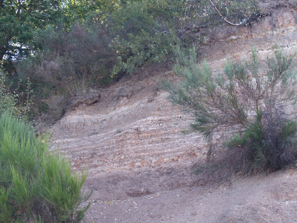
BEAUMONT. Beaumont Red Crag Outlier (TM 180 246), Tendring district.
An isolated patch, or outlier, of Red Crag, about a quarter of a square mile in size, caps the top of the hill occupied by Beaumont Hall. It is one of the few fragments of a once continuous deposit of Red Crag across north Essex that has been almost entirely destroyed by erosion. The Red Crag in this part of Essex consists of loose sand with abundant fossil shells and the fossils of other marine animals that lived in the Red Crag Sea that existed about 2 million years ago. Fossil shells are visible on footpaths and in stream banks hereabouts. The geologist John Brown published a list of fossils from here in 1846. Private land. Access only available on public footpaths.
BRENTWOOD. Thorndon Country Park, including Little Warley Common (TQ 604 915), Brentwood district.
Thorndon Country Park has some interesting landforms which enable the geology to be appreciated. To the south a spread of glacial gravel is dissected by several streams, which have cut through the Claygate Beds exposing the underlying London Clay. Glacial gravel is well exposed in a gravel cliff at the east end of the park with a signboard explaining the geology. A smaller exposure of glacial gravel exists in a gravel pit at Scrub Hill on Little Warley Common to the west. A geological trail guide is being drafted.
BUCKHURST HILL. Lord’s Bushes (TQ 413 935), Epping Forest district.
The woodland sits on an extensive patch of Woodford Gravel, the origin of which is not entirely clear. The pebble assemblage indicates that it was deposited by a northward-flowing river flowing from what is now the Weald northwards across East London to join the Thames, which at that time flowed across north Essex and Suffolk. The gravel may be over 700,000 years ago. There are exposures of gravel in the banks of ponds. (Lord’s Bushes adjoins Knighton Wood which is in the London Borough of Waltham Forest).
CHAFFORD HUNDRED. Chafford Gorges Nature Park (TQ 599 793), Thurrock district.
Chafford Gorges Nature Park is the finest area for geology in south Essex. Spectacular cliffs of Upper Chalk can be seen which are a legacy of quarrying for the Portland Cement industry. The Chalk is overlain by Thanet Sand and gravels from former routes of the Thames during the Ice Age. There are also several fine sarsen stones around the rim of Grays Gorge. The park consists of seven geological sites (Grays Gorge, Lion Gorge, Lion Pit Tramway Cutting SSSI, Millwood Sand Cliff, Sandmartin Cliff, Warren Gorge and Wouldham Cliff), which are under the control of Essex Wildlife Trust. Lion Pit Tramway Cutting SSSI is one of the most important of the County’s SSSIs, yielding evidence of human occupation on the banks of the Thames 200,000 years ago. The visitor centre has fine views overlooking Warren Gorge. A geological trail guide is available.
CLAVERING. Clavering Swallow Hole (TL 4764 3175), Uttlesford district.
A swallow hole is a depression in the ground in a limestone or chalk area into which a stream disappears underground. This example currently takes the form of a two metre wide solution hole in the chalk bedrock of the river. It is the route by which water flows into the chalk aquifer. Discovered by the Environment Agency. It is choked with debris and usually not visible due to the growth of vegetation. Access to the stream bed is hazardous. View from the road only.
DANBURY. Buell Spring (TL 7839 0451), Chelmsford district.
Spring issuing clear water from a cast iron pipe. Remains of pumping station. Spring originates from the spring line that runs right around Danbury Hill (from between the Danbury Gravel and the London Clay). Historically important as the water supply for the area. Of particular interest is the accumulation of ‘bog-iron’ nearby – a cementing of the soil by the iron compounds leached out of the gravel. Land owned by the National Trust.
DANBURY. Danbury Common Gravel Pits (TL 784 047 and TL 781 045), Chelmsford district.
Deep and extensive disused and overgrown gravel pits on east and west sides of Danbury Common (two separate patches of gravel) which provide visible sections through the Danbury Gravels – gravel that accumulated on the ice margin, where its southward progress was prevented by the London Clay high ground. Owned by the National Trust. Eastern pits heavily used by mountain bikers. The higher parts of the western pits are very sandy and occupied by badgers.
EAST MERSEA. Cudmore Grove Cliffs and Foreshore, part of Colne Estuary SSSI (TM 068 146), Colchester district.
The cliffs at Cudmore Grove Country Park provide superb exposures of gravels laid down by the Thames-Medway River during a glacial period 300,000 years ago. Organic sediments at beach level sometimes yield fossils, including mammal bones, that indicate that they were deposited during an interglacial period. Also exposed on the foreshore are deposits from a more recent interglacial period, the Ipswichian interglacial (120,000 years old), and known as the ‘hippo site’ due to the presence of hippopotamus bones. (see also East Mersea Coopers Beach ‘Restaurant site’).
EPPING. Wintry Wood Brick Pit (TL 469 035), Epping Forest district.
Disused brick pit in Wintry Wood adjacent to Brickfield Business Centre (formerly Wintry Park Brick & Tile Works). Steep banks with some Anglian Till (Chalky boulder clay) visible in tree roots. This pit is the only place in Essex on public land where direct evidence of the presence of an ice sheet can be seen. The pit is in the Lower Forest (part of Epping Forest). Layby for parking nearby.
EPPING FOREST. Blackweir Pond (TQ 423 978), Epping Forest district.
As the glaciers at the edge of the Anglian ice sheet slowly melted they dumped great quantities of glacial moraine, at their margins. These mounds are called kames, or more accurately kame terraces, and one of these is preserved as a patch of gravel nearly a kilometre long that follows the contour of the valley south of Great Monk Wood. Blackweir pond is one of the former gravel pits that worked this gravel. Blackweir Pond has been described as the most picturesque of all the Epping Forest ponds.
EPPING FOREST. Loughton Brook Meanders, local geological site (TQ 418 968), Epping Forest district.
Meanders are a common feature of lowland rivers but usually they are large making it difficult to appreciate them from ground level. Loughton Brook has a fine group of small-scale, slightly incised meanders which are easy to study and accessible to visitors. The site is in a woodland setting on the edge of Epping Forest within walking distance of Loughton town centre.
FINCHINGFIELD. Finchingfield Boulder (TL 6849 3290), Braintree district.
A splendid boulder of basalt 85 centimetres (nearly 3 feet) long lies by the roadside on the left hand side a few metres from the village green on the road north out of the village. This boulder was probably transported south from Northumberland or Scotland by the Anglian ice sheet. Large erratic boulders of basalt are very rare in Essex.
FINGRINGHOE. Fingringhoe Wick Nature Reserve, local geological site (TM 045 195), Colchester district.
Essex Wildlife Trust nature reserve. Fingringhoe Wick was a working gravel quarry until 1959. Visible in many places are mounds and banks of glacial sand and gravel (known locally as Upper St. Osyth Gravel) which was deposited some 450,000 years ago by torrents of meltwater issuing from the Anglian ice sheet, the edge of which was then situated only 12 kilometres west of here. The gravel therefore provides evidence of an exceptionally cold period of the Ice Age. A permanent vertical section through the gravel exists in the centre of the reserve.
GREAT BENTLEY. St. Mary’s Church (TM 108 217), Tendring district.
The parish church of Great Bentley stands on the west side of the largest village green in Essex. The church is unusual as it is largely constructed of ferricrete, an iron-cemented gravel that was quarried locally. This stone, which makes a remarkably durable building material, was formed within local Ice Age gravels as an ‘iron pan’, which can be up to a metre in thickness, at the level of the groundwater table. Ferricrete is one of the few building stones native to Essex.
GREAT DUNMOW. Flitch Way Ballast Pit and Tufa Springs (TL 6195 2160), Uttlesford district.
An old overgrown railway ballast pit adjacent to the railway cutting, which is now the route of the Flitch way footpath. The adjacent cutting provides limited exposures of Kesgrave Sands and Gravels overlain, or butting up against, Anglian till. Also of particular interest are hard-water ‘petrifying’ springs, which are the source of crystal-clear streams that run in the cutting, depositing calcium carbonate ‘tufa’ and encrusting all the objects in the steam bed including leaves and twigs.
GREAT HOLLAND. Great Holland Pits Nature Reserve (TM 204 190), Tendring district.
A former gravel pit in the Cooks Green Gravel (laid down by the Thames-Medway river) that is now an Essex Wildlife Trust nature reserve. No current visible exposure of gravel but there are level areas of gravel present beneath scrub that could easily be cleared to reveal a wide variety of rock types. These are mostly cobbles and boulders left behind by the quarry operations. There is an excellent opportunity here to promote geology by exposing these areas of gravel and allowing visitors to identify rock types and speculate on how they got here. The Cooks Green Gravel is about 600,000 years old.
GREAT TOTHAM. Jubilee Recreation Ground (TL 857 116), Maldon district.
Former gravel pit that is now a large recreation ground in centre of Great Totham village. Steep banks with gravel exposures laid down about 450,000 years as outwash from a glacier that was halted by the high ground of Wickham Bishops, Braxted and Tiptree.
GREAT WAKERING. Star Lane Pits (TQ 939 872), Rochford district.
The only place in Essex where a visible section of brickearth (loess) can be found. Low cliffs of brickearth can be seen adjacent to footpaths in this pit which is important for its wildlife. Loess is a fine silt which originated as a wind-blown (aeolian) dust carried great distances from cold, dry land close to an ice sheet to settle and be compacted to form a sedimentary rock. It was probably deposited during the most recent glaciation of Britain (at least 20,000 years ago) although it is very difficult to date and some may be older.
HADLEIGH. Hadleigh Castle Landslip, local geological site (TQ 810 860), Castle Point district.
The most impressive London Clay landslip in Essex. The severe effects on the castle can be clearly seen.
HADLEIGH. Hadleigh Country Park (TQ 799 868), Castle Point district.
Fine undulating landscape of London Clay, overlain by Claygate Beds and Bagshot Sand. The exposure of Bagshot Sand created in 2007 has been obscured by the Olympic cycle track, but a new exposure was created in 2016. Site of British Geological Survey’s 1973 Hadleigh borehole. Fine views over Thames to Kent.
HADLEIGH. Shipwrights Wood, local geological site (TQ 795 871), Castle Point district.
Steep slopes of London Clay, Claygate Beds and Bagshot Sand with landslips. Best woodland in Essex for natural landforms.
HARWICH. Harwich Foreshore SSSI (TM 263 320), Tendring district.
This locality is particularly important as the best exposure of the ‘Harwich Stone Band’, the most distinctive of the ash bands in the Harwich Formation at the base of the London Clay which contains volcanic ash from explosive volcanic eruptions in Scotland during Eocene times some 50 million years ago. The stone band makes this part of the coast the only naturally occurring rocky shore along the entire distance between Norfolk and Kent and may even be the reason for the existence of the Harwich peninsula. The foreshore is also of prime importance for London Clay fossils, particularly for fossil fruits and seeds from the Eocene rainforest. Also found are fossil sharks’ teeth amongst the beach shingle.
HATFIELD FOREST. Hatfield Forest Boulders (TL 541 198), Uttlesford district.
On the southern edge of the lake were three partially-submerged and largely inaccessible boulders, two of Hertfordshire puddingstone (the largest, 135 x 90 x 70 cm in size) and one of sandstone (140 x 110 x 70 cm). They were discovered when the lake was created in about 1750. Adjacent to the Shell House a boulder of limestone(?) (80 x 45 cm) protrudes from the ground. The National Trust has now moved several of the lakeside boulders to near the Shell House so they are more accessible.
HIGH BEACH. High Beach Viewpoint (TQ 411 981), Epping Forest district.
The high ground around the King’s Oak inn is capped with ‘Pebble gravel’ (Stanmore Gravel) which may have been deposited by an unknown river that flowed north from the Weald of Kent to join the ancestral Thames (gravels of similar composition occur at the top of Shooters Hill on the south side of the Thames). Well-rounded pebbles from this gravel are revealed on the many footpaths hereabouts. Beneath the gravel is Bagshot Sand which is visible on the steeply-sloping paths to the north-west of the inn. Many similar high points exist such as Billericay, Havering-atte-Bower, the Langdon Hills and Warley.
HULLBRIDGE. Hullbridge Foreshore (TQ 804 955), Rochford district.
Prehistoric land surface, perhaps as much as 8,000 years old, is revealed at low tide. Peat beds can be seen with evidence of human occupation in the form of Mesolithic flint implements. Sea level was then much lower and the site lay well inland. Important site for understanding sea level change. Beware of intertidal mud.
INGATESTONE. Ingatestone Boulders (TQ 6511 9967 and TQ 6511 9959), Brentwood district.
Two well known sarsen stones are at the junction of the High Street and Fryerning Lane (TQ 6511 9967), the largest one standing one metre above ground. Another stone is situated a short distance away adjacent to the south door of St. Edmund and St. Mary Parish Church in the High Street (TQ 6511 9959). The latter stone stands 90 centimetres above the ground and the church guidebook states that it was originally buried beneath the north wall. Local legend claims that these three stones were once part of a single large boulder but sarsens are extremely tough rocks and there is no sign of freshly broken surfaces. They were undoubtedly separate finds; glacial erratic boulders ploughed up from local fields or more likely excavated from the local gravel pits around Fryerning and brought to the town centre for practical or religious reasons.
LANGDON HILLS. Langdon Hills Country Park (TQ 683 866), Basildon district.
London Clay and Claygate Beds with Bagshot Sand capping the highest ground. This in turn is capped by Stanmore Gravel (formerly called ‘pebble gravel’), the origin of which is still not fully understood. Disused sand and gravel pits exist in the woods. Spectacular views over the Thames Estuary. Part of the site is in Thurrock District.
LEXDEN. Lexden Springs Nature Reserve (TL 973 253), Colchester district.
In Spring Lane, off Lexden Road, is a patch of ancient meadowland which is generally rich in wild flowers. Here a natural spring issues from the junction of the Kesgrave Sands and Gravels and the underlying London Clay.
LITTLE WIGBOROUGH. St. Nicholas Church (TL 980 145), Colchester district.
This 15th century church was badly damaged in the 1884 earthquake, the roof was completely stripped of its tiles and several pieces of masonry fell from the tower. Although over 1,200 buildings in east Essex suffered badly, it is one of the few that was photographed at the time and can still be recognised today. Inside the building a brass plaque on the wall of the tower commemorates this event and the rebuilding of the church in 1886.
MAYLANDSEA. Maylandsea Foreshore, part of the Blackwater Estuary SSSI (TQ 907 035), Maldon district.
The foreshore on the east bank of Lawling Creek,north of Maylandsea, has yielded large numbers of London Clay fossils, particularly crustacean remains, such as lobsters. The SSSI citation states that this section of ‘soft rock’ coastline is of national geological importance. The site demonstrates the maximum transgressive extent of the London Clay, and contains a deeper-water fish fauna than is found at the Isle of Sheppey in Kent. These sediments make up the deepest water facies known in the London Clay, and the assemblage of fossils reflects this, with species which are not seen at Sheppey or other sites.
MISTLEY HEATH. Furze Hill Gravel Pit (TM 122 309), Tendring district.
The disused gravel pit at Furze Hill has a few minor exposures of Waldringfield Gravel, the oldest deposit in Essex from the former course of the River Thames and at least 650,000 years old. A coarse, iron-stained gravel can be seen in small excavations made by rabbits, and pebbles from the gravel are on the paths and in the roots of fallen trees. The gravel appears to contain a high proportion of ‘exotic’ pebbles that clearly have been carried some distance by the Thames, such as well-rounded pebbles of white vein quartz (from North Wales?). The wood is privately owned but publicly accessible and the Essex Way, a long distance public footpath, runs along the northern boundary.
NEWPORT. The Leper Stone (TL 5199 3496), Uttlesford district.
A large coarse-grained sarsen stone 1.7 by 1.2 metres in size known as the Leper Stone sits upright on the grass verge on the side of the road at the north entrance to the village. This is the best known erratic boulder in north Essex. Adjacent to this is a wall constructed largely of blocks of clunch, a hard variety of chalk formerly used for building.
PURFLEET. Purfleet Submerged Forest (TQ 5445 7871), Thurrock district.
Part of a submerged forest, between 5,000 and 6,000 years old, consisting of fallen tree trunks and roots, is exposed on the Thames foreshore. This site and other submerged forests along the Thames (e.g. at Rainham nearby) have been studied since 1665. This site has educational importance in the interpretation of sea level changes since the end of glacial conditions some 10,000 years ago. The forest can be seen only at low tide.
SAFFRON WALDEN. The Gibson Boulders, local geological site (TL 5369 3817), Uttlesford district.
At the junction of Gibson Gardens and Margaret Way is a mound of grass and trees containing at least 25 glacial erratic boulders of varying sizes. At least 10 different rock types are represented. The largest is a slab of colourful puddingstone 1.2 metres long. The site also has great historic interest. The Gibson Gardens estate was built on land which was formerly the gardens owned by George Stacey Gibson (1818-1883), naturalist, who had a great interest in geology. An 1877 map shows this mound to be the site of his summer house and it seems certain that he accumulated these boulders in his garden. They were almost certainly gathered from the farmland that he owned in the vicinity.
SAFFRON WALDEN. Limefields Pit Nature Reserve (TL 541 396), Uttlesford district.
Disused chalk quarry less than 10 minutes walk from the town centre. The floor of the pit is occupied by housing. A buffer zone between the houses and the chalk face is an Essex Wildlife Trust nature reserve. The 6 metre high face is a fine exposure of Upper Chalk. The access gate is locked and the access is available by contacting the nature reserve warden. However, the face can be clearly seen from the road.
ST. OSYTH. Colne Point Shingle Spit, part of Colne Estuary SSSI (TM 108 125), Tendring district.
Colne Point is the best example in Essex of a shingle spit. The spit is 4 kilometres (2.5 miles) long and is nearly all that remains of a much larger area that existed in the 19th century but has now mostly been developed by the seaside holiday industry. It is of great interest for studying the movement of shingle and the development of shingle structures. It is an Essex Wildlife Trust reserve. Day permits to visit are available from the Trust.
ST. OSYTH. St.Osyth Priory Gatehouse (TM 121 157), Tendring district.
Erected in 1481, the battlemented gatehouse of St. Osyth Priory is one of the finest examples in Britain of the use of flint ‘flushwork’. Flushwork is the name given to the technique of setting ‘knapped’ flints (flints skilfully worked to produce a flat face) into a wall, often in intricate patterns alongside another stone such as limestone. St. Osyth’s Priory is privately owned and no longer open to the public but the gatehouse can be viewed from the green open space between the gatehouse and the road where there is also car parking.
SOUTH OCKENDON. Davy Down Sarsen Stone (TQ 592 800), Thurrock district.
Davy Down Riverside Park forms part of the Mar Dyke Valley, a delightful valley with steep, wooded sides and a grazed floor that can be seen from the M25 motorway. The valley runs along the northern side of the Purfleet Anticline, an east-west trending ridge of chalk between Purfleet and Grays. Also of interest at Davy Down is the pumping station, built in 1928 with a 50 metre deep borehole down into the Chalk. It is still used today for pumping water for use in the local area. Outside the pumping station is a remarkable sarsen stone – probably the finest example in Essex. The sarsen is 1.6 metres square and has fine mammillated surfaces. It formerly stood outside Marley’s works on the south side of Stifford Road, South Ockendon and is understood to have been found in the gravel pit south of the works.
TOLLESBURY. Woodrolfe Creek Saltmarsh (TL 969 105), Maldon district.
The best and safest place to view saltmarsh in Essex, with its creeks and tidal flats, is at Tollesbury. Here the marsh is criss-crossed by paths to enable boat owners to reach their vessels.
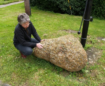
UGLEY GREEN. Ugley Green Puddingstone (TL 524 271), Uttlesford district.
Beside the green, next to the village pump, is a fine, rounded and colourful boulder of Hertfordshire puddingstone 1.2 metres long.
WALTON-ON-THE-NAZE. The Naze Cliffs SSSI (TM 266 235), Tendring district.
The finest geological site in Essex. Classic cliff section in London Clay, Red Crag, brickearth and Thames Gravel (Cooks Green Gravel). Volcanic ash bands and faults in London Clay. Classic rotational landslips. Diverse fauna of fossils from Red Crag and London Clay. Site of international importance. Geological guide available from GeoEssex.
WENDENS AMBO. Wenden Place Boundary Wall (TL 512 363), Uttlesford district.
On the bend of the main road opposite the church is a high, ancient wall, which is remarkable for the variety of local rocks used in its construction, including many large boulders. The largest is a puddingstone 1.4 metres long. The wall is a grade 2 listed building.
WEST THURROCK. Dolphin Chalk Quarry (TQ 571 780), Thurrock district.
Formerly known as the Metropolitan Works Quarry, the Dolphin Chalk Quarry is situated between Stonehouse Lane and Canterbury Way (the Dartford Tunnel approach road) and contains a cement manufacturing plant and an industrial estate. The 20 metre (65 foot) high vertical chalk face that forms the western side of the quarry is the most remarkable chalk cliff in Essex as it shows regularly spaced bands of flint nodules which represent cycles of climate change (Milankovitch climate cycles) during the Cretaceous period some 80 million years ago. These flint bands are not present elsewhere in Essex and, due to aspect and differential weathering, are not even clearly visible in the adjoining quarry.
WOODHAM MORTIMER. St. Margaret’s Church (TL 822 052), Maldon district.
The parish church of St Margaret’s is a fine example of the use of local septarian nodules for building construction, which are clearly visible in the external walls.
WRABNESS. Wrabness London Clay Cliffs and Foreshore, part of Stour Estuary SSSI (TM 172 323), Tendring district.
The London Clay cliffs on the River Stour at Wrabness are the highest vertical cliffs in Essex and consist of the upper part of the Eocene Harwich Formation and the lower few metres of the Walton Member of the London Clay. They provide the best onshore exposure of the Harwich Formation. The Wrabness cliffs are of particular interest because they contain a complete sequence of bands of volcanic ash, which probably originated from volcanoes in Scotland. These ash bands are present from the Harwich Stone Band to the top of the formation. Over 30 separate ash layers occur throughout some 10 metres of clay and silty clay, which was deposited in a subtropical sea about 50 million years ago. The site has also yielded an important fossil flora (preserved in concretions).