Rochford
The following sites have been selected to represent the different aspects of geology and landscape in the district. Not all sites have something to see; many are solely of historical interest as a record of an important or interesting discovery.
Some sites are not strictly geological but have a geological connection. Geological sites are therefore defined in their widest sense and include, for example, buildings, walls, wells, spas, springs, graves, boreholes, plaques, landslips and viewpoints.
This is not a complete list of geological sites in the district. Others will be added and descriptions expanded as further research is carried out.
Important note:
Not all of the sites here described are accessible. Some sites are on private land and can only be viewed from footpaths that pass through or alongside the site. Inclusion of a site on this list does not, therefore, imply any right of access. Please remember not to trespass on private land.
Sites of Special Scientific Interest (SSSIs)
Foulness Island and Maplin Sands (part of Foulness SSSI) (TR 048 954)
The Foulness coastline is of considerable geomorphological interest. At Foulness Point, saltmarsh is fringed by a prominent bank of empty cockle shells known as a ‘chenier ridge’ similar to that at Bradwell-on-Sea. This is the most extensive shell beach in Britain. Maplin Sands is an extensive area of mudflats and sand banks off the coast of Foulness. Access to Foulness Island is restricted to those that live and work there. Permission to visit must be obtained from the Ministry of Defence who own the entire island and use it as a base for artillery ranges over the Maplin Sands.
Local Geological Sites (LoGS)
Click the links below to read and download the district report and LoGS citations for Rochford District Council.
Rochford District Council – Report on Local Geological Sites – Revised September 2025
RoG1 – Hockley Spa Pump Room, Hockley (TQ 841 925)
Original pump room of Hockley Spa is a prominent building in the town and one of the finest pump rooms in Britain. A grade 2 listed building. Building is privately owned but can be seen from the road.
RoG2 – Hockley Woods (TQ 833 924)
The foundations of the woods is London Clay overlain by Claygate Beds and Bagshot Sand. On the highest ground there are patches of Oakwood Gravel, laid down by the River Medway perhaps as much as 700,000 years ago.
RoG3 – River Crouch Foreshore, Hullbridge (TQ 804 955)
Prehistoric land surface, perhaps as much as 8,000 years old, is revealed at low tide. Peat beds can be seen with evidence of human occupation in the form of Mesolithic flint implements. Sea level was then much lower and the site lay well inland. Important site for understanding sea level change. Beware of intertidal mud.
RoG4 – Ferricrete Poulder, Paglesham (TQ 9235 9323)
A boulder of ferricrete sits on the verge on the south side of a surfaced farm track (public footpath) that runs northwest from Paglesham Churchend. Ferricrete is an iron-cemented flint gravel, formed from the evaporation of groundwater that contains dissolved iron compounds.
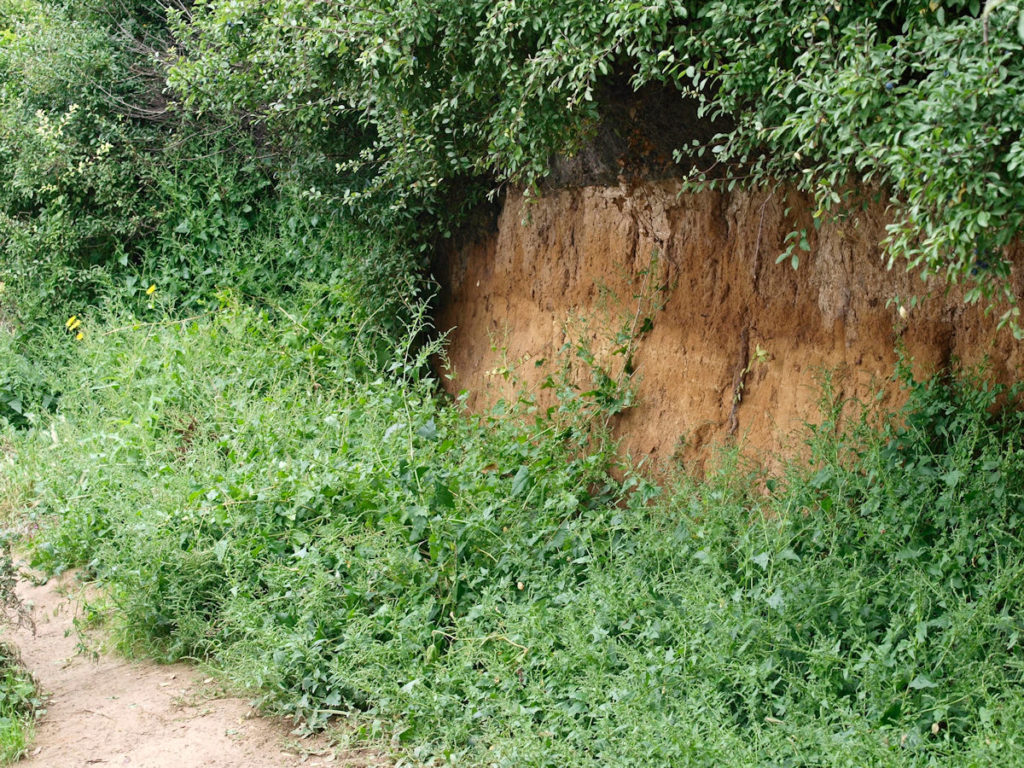
LoG5 – Star Lane Pits, Great Wakering (TQ 939 872)
The only place in Essex where a visible section of brickearth (loess) can be found. Low cliffs of brickearth can be seen adjacent to footpaths in this pit which is important for its wildlife. Loess is a fine silt which originated as a wind-blown (aeolian) dust carried great distances from cold, dry land close to an ice sheet to settle and be compacted to form a sedimentary rock. It was probably deposited during the most recent glaciation of Britain (at least 20,000 years ago) although it is very difficult to date and some may be older.
Other Sites of Geolocical Interest
Baldwins Farm and Barling Hall Pits, Barling (TQ 935 899)
The former gravel pits at Barling excavated the Barling Gravel, an extensive spread of gravel and sand laid down by the Thames-Medway river when it was a large, braided river flowing north across this part of Essex. The Barling Gravel is about 250,000 years old and is part of the Low Level East Essex Gravel and forms the lowest ‘tread’ in this staircase of terrace deposits fringing the Essex coast. Fossils found in the gravel have included the bones of elephant, mammoth, horse, aurochs, bison, red deer, giant deer and possibly rhinoceros. However, of most importance was the discovery, in 1983, of interglacial sediments rich in animal and plant fossils in a channel cut into London Clay bedrock and overlain by the Barling Gravel. The channel sediments yielded molluscs and plant remains that imply that they were deposited in fully interglacial conditions about 300,000 years ago. The presence of humans on the banks of the Thames-Medway river at this time is indicated by the discovery of numerous Palaeolithic flint implements including at least 10 handaxes.
Doggetts Pit, Rochford (TQ 880 915)
Doggetts Pit has some very limited exposures of Rochford Gravel. Rochford Gravel is an infilling of the Rochford Channel which is thought to have been cut by the Thames about 400,000 years ago shortly after the diversion of the river by the Anglian ice sheet. The Rochford Channel is therefore an upstream equivalent of the famous Clacton Channel (see under Tendring District). Patterned ground with fossil ice-wedge polygons are present in the adjacent fields and can be seen on aerial photographs taken during dry Summers. The site is now a popular fishing lake with sandy gravel exposed in the banks.
Hambro Hill Sand Pits, Rayleigh (TQ 8150 9194)
Hambro Hill, just north of Rayleigh town centre, consists of the sandy clay of the Claygate Beds overlain by a thick and extensive outcrop of Bagshot Sand. There have been several sand pits here over the years. One of the many pits working the clay and the sand here was Hambro Hill Brickworks, which was active between about 1899 and 1920. These pits have provided some of the most magnificent exposures of Bagshot Sand to be seen anywhere in Essex, with as much as 10 metres thickness of sand sometimes being visible. This sand is a truly marine deposit and distinctly different in character to the equivalent rocks at Bagshot in Surrey, after which the formation is named. There are still some exposures of Bagshot Sand on Hambro Hill, but the land is private land with no public access. It now consists of several industrial units and a wood yard.
Rayleigh Brick and Tile Works (site of Down Hall Brickworks), Rayleigh (TQ 810 918)
During an Essex Field Club visit to Rayleigh in April 1925 members visited the pit then worked by the Rayleigh Brick and Tile Company south-east of the railway line. An extensive section through the sandy clay known as Claygate Beds was then visible. A large number of fossils were recovered from this pit, including corals, fish remains and at least 30 species of molluscs. The site of the brickworks has now been developed and is now occupied by roads called Lower Lambricks and Upper Lambricks. The fossils from here are in the Natural History Museum, London and the Essex Field Club’s collection.
Rayleigh Geological trail (TQ 807 909)
Rayleigh Town Centre is the subject of a small ‘geological trail guide’ published in 1995 in aid of the Rayleigh Parish Centre. The trail starts with Holy Trinity Church at the northern end of the High Street and takes in several other buildings in the town centre. The stones used in the construction of the buildings are described and we learn how and when they were formed and where in the world they are likely to have come from. Churches and high streets in Essex a full of natural stones from local rocks used hundreds of years ago to modern, highly polished decorative stone from quarries on the other side of the world. Rayleigh is one of the few places in Essex with a published building stones guide.