The following sites have been selected to represent the different aspects of geology and landscape in the district. Not all sites have something to see; many are solely of historical interest as a record of an important or interesting discovery.
Some sites are not strictly geological but have a geological connection. Geological sites are therefore defined in their widest sense and include, for example, buildings, walls, wells, spas, springs, graves, boreholes, plaques, landslips and viewpoints.
This is not a complete list of geological sites in the district. Others will be added and descriptions expanded as further research is carried out.
Important note:
Not all of the sites here described are accessible. Some sites are on private land and can only be viewed from footpaths that pass through or alongside the site. Inclusion of a site on this list does not, therefore, imply any right of access. Please remember not to trespass on private land.
Sites of Special Scientific Interest (SSSIs)
No geological SSSIs have been notified in the district.
Local Geological Sites (LoGS)
Brentwood District Council – Report on Local Geological Sites – February 2022
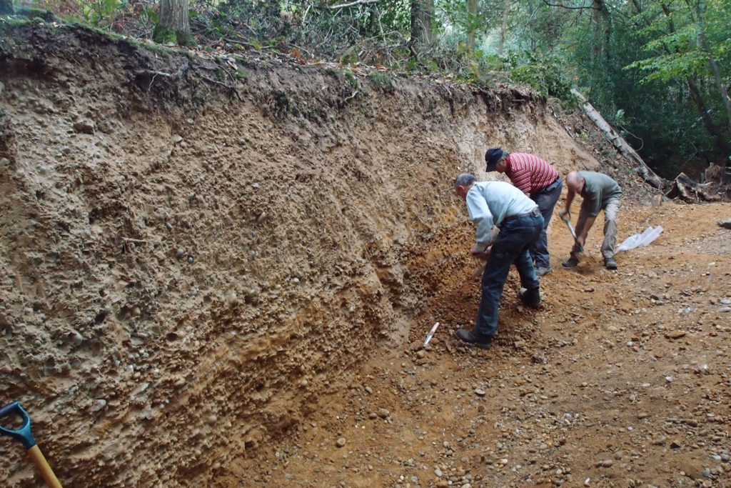
BLACKMORE. College Woods (TQ 623 015)
Within College Wood (private land with no public access), these disused gravel pits were dug into Ice Age gravels of unclear origin, with the potential for future research. The gravel in College Wood contains vein quartz, quartzite and rare Lower Greensand pebbles, a rather different pebble assemblage compared to occurrences elsewhere in the area.
Blackmore College Woods Logs Citation – February 2022
BLACKMORE. Post Office Stone (TQ 6033 0187)
Next to the post office in the village of Blackmore is a small boulder of basalt or dolerite, 38 cm x 34 cm x at least 20 cm. Erratic boulders of igneous rock such as this are rare in Essex. The stone may be much larger as it is buried in the ground and only part is visible. It was probably transported to Essex from Northern England by the Anglian ice sheet about 450,000 years ago.
Blackmore Post Office Stone Logs Citation – February 2022
BRENTWOOD. Former pit of Brentwood Brickworks (TQ 586 932)
A classic site in the London Clay/Claygate Beds that produced a large number of fossils, many of which are now in London’s Natural History Museum. It has been cited in numerous scientific papers. It ceased working and became overgrown in the 1980s and is now occupied by an industrial estate. The steep sides of the pit can still be seen but no access is available. An historical site only.
Brentwood Brickworks Logs Citation – February 2022
BRENTWOOD. Thorndon Country Park North (TQ 604 915)
Thorndon Country Park has some interesting landforms which enable the geology to be appreciated. To the south a spread of glacial gravel is dissected by several streams, which have cut through the Claygate Beds exposing the underlying London Clay. Glacial gravel is well exposed in a gravel cliff at the east end of the park with a signboard explaining the geology. A smaller exposure of glacial gravel exists in a gravel pit at Scrub Hill on Little Warley Common to the west. A geological trail guide is available to download on site.
Thorndon Country Park North Logs Citation – February 2022
DODDINGHURST. All Saints Church (TQ 5891 9900)
The external walls of the church contain many different rock types of geological interest and several fossils. The Victorian vestry is of particular interest.
Doddinghurst All Saints Church Logs Citation – February 2022
GREAT WARLEY. Coombe Green Sand Pit (TQ 576 904)
In a triangular wood bounded by three lanes is a former sand pit with minor exposures of Bagshot Sand. The pit was visited by the Geologists’ Association in 1915 and the director noted that it was very fine sand with a great abundance of the minerals epidote and blue tourmaline.
Great Warley Coombe Green Sand Pit Logs Citation – February 2022
GREAT WARLEY. Holdens Wood (TQ 591 913)
The disused pits in Holdens Wood, on private land, but viewable from footpath, are scientifically important because are the ‘type-site’ for the Warley Gravel, now considered to be part of the Stanmore Gravels, that were laid down by north-flowing tributaries to the ancestral Thames.
Great Warley Holdens Wood Logs Citation – February 2022
INGATESTONE. Ingatestone Boulders (TQ 6511 9967 and TQ 6511 9959)
Two well known sarsen stones are at the junction of the High Street and Fryerning Lane (TQ 6511 9967), the largest one standing one metre (3’3″) above ground. Another stone is situated a short distance away adjacent to the south door of St. Edmund and St. Mary Parish Church in the High Street (TQ 6511 9959). The latter stone stands 90 centimetres (3 feet) above the ground and the church guidebook states that it was originally buried beneath the north wall. Local legend claims that these three stones were once part of a single large boulder but sarsens are extremely tough rocks and there is no sign of freshly broken surfaces. They were undoubtedly separate finds; glacial erratic boulders ploughed up from local fields or more likely excavated from the local gravel pits around Fryerning and brought to the town centre for practical or religious reasons.
Ingatestone Boulders Logs Citation – February 2022
NAVESTOCK. Millennium Stone (TQ 5460 9613)
A giant boulder of ferricrete, excavated from a nearby field, sits on a concrete plinth by the road. 2.1 metres by 1.5 metres (7 feet by 5 feet) in size it was placed here in 2000 to mark the Millennium.
Navestock Millenium Stone Logs Citation – February 2022
SOUTH WEALD. Langtons Gravel Pit, part of Weald Country Park (TQ 577 947)
The former gravel pit at Langtons is a classic geological site that has been cited in numerous scientific papers for over a century because of the former exposures of the ‘Bagshot Pebble Bed’, the origin of which is controversial. The Bagshot Pebble Beds is at the junction of the Bagshot Sand and the overlying Warley Gravel (also known as Stanmore Gravel or ‘pebble Gravel). No gravel is currently visible and this is an historical site only. The former pit is occupied by Langtons Pond.
Langtons Gravel Pit Logs Citation – February 2022
Other Sites
BRENTWOOD. Harts Wood (TQ 603 923)
Potential exposures of Warley Gravel and Bagshot Sand. Exposures may be available in ravines or stream banks.
KELVEDON HATCH. The Coppice (TQ 573 991)
This public woodland has minor exposures of Warley Gravel and Bagshot Sand in the valley sides.