Colchester
The following sites have been selected to represent the different aspects of geology and landscape in the district. Not all sites have something to see; many are solely of historical interest as a record of an important or interesting discovery.
Some sites are not strictly geological but have a geological connection. Geological sites are therefore defined in their widest sense and include, for example, buildings, walls, wells, spas, springs, graves, boreholes, plaques, landslips and viewpoints.
This is not a complete list of geological sites in the district. Others will be added and descriptions expanded as further research is carried out.
Important note:
Not all of the sites here described are accessible. Some sites are on private land and can only be viewed from footpaths that pass through or alongside the site. Inclusion of a site on this list does not, therefore, imply any right of access. Please remember not to trespass on private land.
Sites of Special Scientific Interest (SSSIs)
Coopers Beach, East Mersea (‘Restaurant Site’) (part of Colne Estuary SSSI) (TM 053 136)
Beneath the beach shingle here is a ‘channel’ infilled with sediments dating from the Ipswichian interglacial period (125,000 years old) containing fossils including hippopotamus bones (see also Cudmore Grove, East Mersea). The sediments are beneath the beach and therefore not normally accessible.
Cudmore Grove Cliffs and Foreshore, East Mersea (part of Colne Estuary SSSI) (TM 068 146)
The cliffs at Cudmore Grove Country Park provide superb exposures of gravels laid down by the Thames-Medway River during a glacial period 300,000 years ago. Organic sediments at beach level sometimes yield fossils, including mammal bones, that indicate that they were deposited during an interglacial period. Also exposed on the foreshore are deposits from a more recent interglacial period, the Ipswichian interglacial (120,000 years old), and known as the ‘hippo site’ due to the presence of hippopotamus bones. (see also East Mersea Coopers Beach (‘Restaurant site’).
Marks Tey Brick Pit SSSI (TL 911 243)
Marks Tey Brick Pit provides exposures of uniquely important Pleistocene sediments, which have yielded a continuous pollen record through the entire Hoxnian Interglacial period (400,000 years ago). No other site in the British Isles has so far produced a comparable vegetational record for this or any other interglacial. Of considerable interest also are the laminations (seasonal layers) within these lacustrine (lake) sediments which have made it possible to estimate the duration in years of the Hoxnian Interglacial. Private land. Permission to visit is required from the brick company.
Wivenhoe Gravel Pit SSSI (TL 050 235)
The SSSI is the type locality for the Wivenhoe Gravel, a gravel deposited by the early Thames during two cold stages of the Ice Age. Interbedded with the gravel is an interglacial deposit containing fossils from a warm or temperate climate. Humanly-worked flint flakes have also been found. The deposits are over 500,000 years old. The conserved area of the SSSI is an overgrown flooded depression just inside the Colchester district. Restoration plan for part of quarry includes a fine Sand Martin cliff at TM 0505 2202. Private land, permission to visit is required from the quarry owners.
Local Geological Sites (LoGS)
Click the links below to read and download the district report and LoGS citations for Colchester City Council.
Colchester City Council – Report on Local Geological Sites – September 2025
CoG1 – Church Lane Gravel Cliff, Stanway
The disused gravel pits south of Church Lane, Stanway have mostly been infilled and much of the land is now occupied by housing. However, a vertical cliff of Kesgrave Sands and Gravels (pre-diversion Thames gravel) is preserved south of Church Lane just west of the new Stanway Western Bypass.
CoG2 – Fingringhoe Wick Nature Reserve
Fingringhoe Wick was a working gravel quarry, known as Freshwater Pit, between 1924 and 1959. Visible in many places are mounds and banks of glacial sand and gravel (known as Upper St. Osyth Gravel) which was deposited some 450,000 years ago by colossal torrents of meltwater issuing from the Anglian ice sheet, the edge of which was then situated only 12 kilometres west of here.
CoG3 – Greenbank House Sarsen Stones, Boxted Church Road
Four sarsen stones are situated by the entrance to Greenbank House in Boxted Church Road near the junction with Holly Lane. Sarsens are extremely hard boulders of sandstone formed around 55 million years ago and were brought here by the owner from farmland in the nearby Stour Valley.
CoG4 – Greenstead Puddingstone
This very fine and colourful puddingstone is in mint condition and shows no sign of being transported by a river or an ice sheet. It was presumably found when the housing estate was constructed in the 1960s.
CoG5 – Greenstead Sarsen Stone
A sarsen stone stands by a bus stop in Avon Way. It is very unusual to see a sarsen stone in such an urban setting. It is the largest of several sarsen stones in the vicinity, presumably all found when the housing estate was constructed in the 1960s.
CoG6 – Lexden Springs Nature Reserve
In Spring Lane, off Lexden Road, is a patch of ancient meadowland where a natural spring issues from the junction of the Kesgrave Sands and Gravels and the underlying London Clay.
CoG7 – Rams Farm Sarsen Stone, Fordham
At Rams Farm, Fordham is a fine sarsen stone standing upright by the roadside. The boulder was moved to its present position in the 1960s. This may be the stone at Fordham referred to in 1914 “in a roadside bank”.
CoG8 – Wormingford Mere
Wormingford Mere is a deep, dark body of water, fed by springs and joined on the northern side to the River Stour through a small cut. It is thought to be a glacial solution feature or pingo left by the retreating ice sheet.
CoG9 – Mount Bures Boulders
Two boulders of puddingstone and sarsen can be seen outside the churchyard entrance and the adjacent Mount Bures Hall.
CoG10 – Priors Pit, Fingringhoe
Cliff face from disused pit once worked by the Prior Family (using coasters to take aggregate from the Colne at Fingringhoe Ballast Quay to London via the River Thames). The gravel here provides evidence of an exceptionally cold period of the Ice Age, a time when Essex was barren of virtually all life.
CoG11 – Ridgnalls Puddingstone, Boxted Church Road
A rare example of a puddingstone in this part of Essex. Probably local derived from local gravel workings in the Kesgrave formation of the ancestral Thames that once flowed across this area.
Other Sites of Geological Interest in the District
Colchester Castle (TL 998 253)
Colchester Castle (a Norman keep) is constructed of septarian nodules (septaria) from the London Clay, probably gathered from the Essex coast.
Lion Walk United Reformed Church spire (formerly Colchester Congregational Church), Colchester (TL 9971 2506)
The top of the church spire fell into the street during the 1884 earthquake and the Illustrated London News at the time published an impressive engraving of the occurrence with people fleeing from the scene. The church has since been demolished but the tower (with its rebuilt spire) was spared and it remains as a prominent landmark in the town shopping centre. It is the tallest church spire in Colchester.
St. John’s Abbey Gatehouse, Colchester (TL 9977 2475)
The fifteenth century gatehouse of St. John’s Abbey is a fine example of the use of knapped flints known as ‘flushwork’.
Roman Town Wall, Colchester (TL 9942 2550)
Colchester’s Roman Wall is constructed of septarian nodules (septaria) from the London Clay, probably gathered from the Essex coast. The septaria are interspersed with layers of brick. The wall was probably constructed in the late 3rd century.
Pits Wood (also known as Gravelpit Wood), Copford (TL 931 234)
Local wildlife site situated in old gravel workings. Wood open to the public. Kesgrave (pre-diversion Thames) sand and gravel visible in banks and thrown out from animal burrows.
Jupes Hill Landslip, Dedham (TM 069 318)
Landslip in the London Clay slopes on the south side of the Stour valley near Dedham. It is reported to have occurred in 1928 on a slope of between 9° and 11½° between the 100 and 65 foot contours. An area of about 260 feet across the slope and 260 feet down was involved in the movement which left a rear scarp of about 8 feet in height. The toe of the slope has now been ploughed away. The Essex Way passes across the top of the landslip. Historical site only as little evidence of the landslip can now be seen. There is evidence of larger, older landslips along this side of the valley.
Greenbank House Sarsen Stones, Great Horkesley (TL 981 321)
Four sarsen stones are situated by the entrance to Greenbank House in Boxted Church Road near the junction with Holly Lane. Each is about 90 x 60 x 40 cm in size and they can be clearly seen from the roadside. The garden of the house contains over 20 sarsens, each one brought here by the owner from farmland in the nearby Stour Valley. Greenbank House is a private residence.
St. Nicholas Church, Little Wigborough (TL 980 145)
This 15th century church was badly damaged in the 1884 earthquake, the roof was completely stripped of its tiles and several pieces of masonry fell from the tower. Although over 1,200 buildings in east Essex suffered badly, it is one of the few that was photographed at the time and can still be recognised today. Inside the building a brass plaque on the wall of the tower commemorates this event and the rebuilding of the church in 1886.
The Rose Inn, Peldon (TL 006 159)
Peldon was at the epicentre of the 1884 earthquake. The Rose Inn was particularly badly damaged and there are numerous contemporary illustrations and photographs of the building soon after the event. A plaque at the rear of the building (installed by the Rural Community Council of Essex in the 1980s) commemorates the earthquake.
St. Mary’s Church, Peldon (TL 989 168)
Peldon Church was situated at the epicentre of the 1884 Colchester earthquake and was badly damaged. The bricked-up nave bearing evidence of the extensive repair work undertaken.
Grave of John Brown, Stanway (TL 940 243)
In Stanway churchyard is the grave of the most famous Essex geologist John Brown (1780-1859), whose collection of nearly 8,000 specimens was bequeathed to the Natural History Museum in London. The grave is unfortunately now covered in lichen and moss and the inscription is barely readable.
Wakes Colne Green Sarsen Stones (TL 897 300)
At the road junction are three sarsen stones by a pond, the largest 100 x 100 x 30 cm in size.
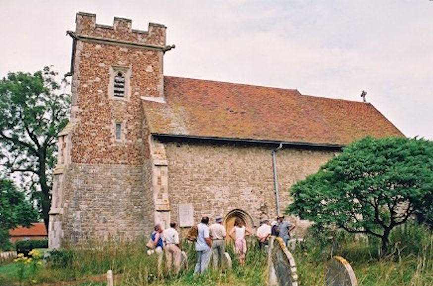
Photo © W.H. George