Uttlesford
The following sites have been selected to represent the different aspects of geology and landscape in the district. Not all sites have something to see; many are solely of historical interest as a record of an important or interesting discovery.
Some sites are not strictly geological but have a geological connection. Geological sites are therefore defined in their widest sense and include, for example, buildings, walls, wells, spas, springs, graves, boreholes, plaques, landslips and viewpoints.
This is not a complete list of geological sites in the district. Others will be added and descriptions expanded as further research is carried out.
Important note:
Not all of the sites here described are accessible. Some sites are on private land and can only be viewed from footpaths that pass through or alongside the site. Inclusion of a site on this list does not, therefore, imply any right of access. Please remember not to trespass on private land.
Sites of Special Scientific Interest (SSSIs)
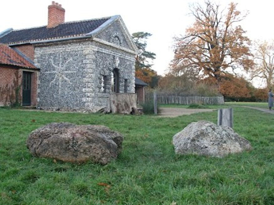
UGLEY. Hall’s Quarry SSSI (also known as Ugley Park Quarry) (TL 519 280)
The complex sequence of sands, gravels and boulder clay at this quarry is important for showing that, during the Anglian cold stage (450,000 years ago), the Thames catchment was repeatedly invaded by ice. The evidence from Ugley is critical in demonstrating that there were at least four of these ice advances, each one depositing a characteristic boulder clay. The quarry is still active but is partly infilled. Two representative sections were intended to be maintained in the northern part of the pit. There are several fine sarsen stones by the road at the entrance to the quarry. Private land. Permission to visit is required from the quarry owners.
Local Geological Sites (LoGS)
Click the links below to read and download the district report and LoGS citations for Uttlesford District Council.
Uttlesford District Council – Report on Local Geological Sites – February 2026
UfdG1 – Alsa Lodge Gravel Pit, Ugley
Alsa Lodge Pit is a disused sand and gravel pit with the potential to provide exposures of glacial gravel left behind by a glacier that filled this valley during the coldest period of the Ice Age about 450,000 years ago. The floor of pit is now occupied by a shooting range and an auction house. This pit was a
UfdG2 – Arkesden Chalk Pit
Disused quarry in the Upper Chalk, cut into the hillside and visible from the road. A fine vertical exposure of Upper Chalk. One of the highest chalk exposures in North Essex.
UfdG3 – Arkesden War Memorial
The war memorial in St. Mary’s churchyard consists of a very large, single boulder of puddingstone 1.7 x 1.7 x 0.8 metres in size. It is not known where this was obtained but it is a fine and unusual use for an erratic boulder.
UfdG4 – Ashdon Meteorite Fall (site of)
The Ashdon meteorite that fell in 1923 is the only meteorite to have been found in Essex. The fall was witnessed by a farm worker in broad daylight on Ashdon Hall Farm and subsequently dug up from a depth of two feet. The site of the fall is therefore historically important and a post commemorating the event was installed next to the site in 2023. The meteorite is now in the meteorite collection at the Natural History Museum, London and is still available for study. A cast of the meteorite can be seen in Saffron Walden Museum. Ashdon Museum also has a cast with a small display on the fall.
UfdG5 – Audley End Sarsen Stone
Fine sarsen stone by the road opposite the entrance to Audley End House (1.1 x 0.9 x 0.5 metres in size).
UfdG6 – Beaumont Hill End Sarsen Stone, Great Dunmow
A large sarsen stone 1.6 metres long sits in the grass on Beaumont Hill almost opposite the junction with Lime Tree Hill. Judging from its weathered surface, it has been in this position for a considerable time, probably for several hundred years.
UfdG7 – Bentfield End End Sarsen Stone, Stansted Mountfitchet
A large sarsen stone 1.2 metres (4 feet) long sits outside a cottage at the junction of Wetherfield and Bentfield End Causeway.
UfdG8 – Buckingham’s Farm End Sarsen Stone, Thaxted
A sarsen stone 90 by 60 centimetres in size sits by the roadside outside the entrance to Buckingham’s Farm.
UfdG9 – Catmere End End Sarsen Stone
A very large sarsen stone 2.1 metres long sits in the long grass by the signpost at the crossroads.
UfdG10 – Chalk Farm Lane Chalk Pit, Newport
Small disused chalk pit just beyond Newport Station on the former access road to Newport Limeworks.
UfdG11 – Clatterbury Lane Puddingstone, Arkesden
Almost hidden in vegetation at the side of Clatterbury Lane to the south of the village is a very large and colourful boulder of Hertfordshire puddingstone (2.0 x 1.3 x 1.0 metres size). It is close to the road and access is difficult.
UfdG12 – Coopers End Farm Boulders, Duddenhoe End
Large Hertfordshire puddingstone (1.6 x 1.4 x 0.55 metres in size) by the entrance to a plant hire company at Coopers End Farm. The boulder is unusual as the base is free of pebbles and therefore takes on the appearance of a sarsen stone.
UfdG13 – Debden Road Chalk Pit, Newport
Very small roadside pit with minor exposure of Upper Chalk overlain by Anglian till (boulder clay) consisting of brown clay with chalk pebbles and other erratics. The till is material dumped by a glacier as it ground its way across the landscape 450,000 years ago. This is one of the few exposures of till in north Essex. The site is adjacent to a layby on the Debden Road.
UfdG14 – Debden Water Gravel Pit, Newport
A small disused gravel pit in the valley of the Debden Water east of Newport. A low cliff of glacial gravel can be seen here which was laid down by torrents of meltwater from the Anglian Ice Sheet 450,000 years ago. In marked contrast to the sedate nature of the valley today. Piles of gravel with large nodular flints can be seen on the floor of the pit.
UfdG15 – Elm Grove Summer House, Saffron Walden
Elm Grove is a group of bungalows for elderly persons, which were built on land which was formerly the rear garden of a property called Elm Grove, built 1828 and demolished in the 1970s. Against the flint boundary wall is a small summer house or grotto, surviving from the former garden. The summer house is remarkable as it is built almost entirely from erratic boulders. There are at least 20 boulders of different rock types but of particular interest is a giant Hertfordshire puddingstone 2.6 x 1.2 metres in size at the base of the south wall, which may be the largest puddingstone in Essex. Elm Grove is private property and permission for access must be obtained from the Estate Manager.
UfdG16 – Farnham Wood Puddingstones, Farnham
A giant boulder of Hertfordshire puddingstone 1.83 metres long sits in a patch of woodland a few metres north of the public footpath. A second, smaller puddingstone sits alongside which is a fragment that has broken off the main mass.
UfdG17 – Fitchway Way Ballast Pit and Tufa Springs, Great Dunmow
An old overgrown railway ballast pit adjacent to the railway cutting, which is now the route of the Flitch way footpath. The adjacent cutting provides limited exposures of Kesgrave Sands and Gravels overlain, or butting up against, Anglian till. Also of particular interest are hard-water ‘petrifying’ springs, which are the source of crystal-clear streams that run in the cutting, depositing calcium carbonate ‘tufa’ and encrusting all the objects in the steam bed including leaves and twigs.
UfdG18 – Freewood Lane Boulder, Elmdon
At the entrance to Freewood Lane is a glacial erratic boulder (80 x 60 x 50 centimetres in size). It is unusual as it consists of Spilsby Sandstone and originates in Lincolnshire. It was brought here by the great Anglian Ice Sheet when it covered almost the whole of Britain 450,000 years ago.
UfdG19 – The Gibson Boulders, Saffron Walden
At the junction of Gibson Gardens and Margaret Way is a mound of grass and trees containing at least 25 glacial erratic boulders of varying sizes. At least 10 different rock types are represented. The largest is a slab of colourful puddingstone 1.2 metres long. The site also has great historic interest and an informative signboard has now been installed.
UfdG20 – Hatfield Forest Erratic Boulders
On the southern edge of the lake were three partially-submerged and largely innaccessible boulders, two of Hertfordshire puddingstone (the largest 1.35 x 0.9 x 0.7 metres in size) and one of sandstone (1.4 x 1.1 x 0.7 metres in size). They were discovered when the lake was created in about 1750. Adjacent to the Shell House a boulder of limestone(?) (80 x 45 cm) protrudes from the ground. The National Trust has now moved several of the lakeside boulders to near the Shell House so they are more accessible.
UfdG21 – Hazel End Sarsen Stone
At the side of the Hazel End Road near the road junction, is a large sarsen stone with a thick band of pebbles running through the centre. It is an unusual sarsen stone in a prominent position.
UfdG22 – The Leper Stone, Newport
A large coarse-grained sarsen stone 1.7 x 1.2 metres in size known as the Leper Stone sits upright on the grass verge on the side of the road at the north entrance to the village. This is the best known erratic boulder in north Essex. Adjacent to this is a wall constructed largely of blocks of clunch, a hard variety of chalk formerly used for building.
UfdG23 – Limefields Pit Nature Reserve, Saffron Walden
Disused chalk quarry less than 10 minutes walk from the town centre. The floor of the pit is occupied by housing. A buffer zone between the houses and the chalk face is an Essex Wildlife Trust nature reserve. The 6 metre high face is a fine exposure of Upper Chalk. The access gate is locked and the access is available by contacting the nature reserve warden. However, the face can be clearly seen from the road.
UfdG24 – Mallows Green Chalk Pit, Manuden
At Mallows Green, south-west of Manuden, is a disused and extremely overgrown chalk pit cut into the hillside adjacent to a public footpath. It dates back to the nineteenth century. It provided exposures of Upper Chalk overlain by an outlier of Lower London Tertiaries (Thanet Sand or Reading Beds) with a layer of green-coated flints (the ‘Bull head bed’) at the junction.
UfdG25 – Newport Chalk Quarry
Newport Chalk Quarry (also known as Chalk Farm Quarry or Newport Limeworks) is the only working chalk quarry in Essex, supplying chalk for agricultural lime. It is coming to the end of its life, with plans for landfill. There are currently fine exposures of Upper Chalk and excellent sections through numerous gravel-filled solution pipes. It is hoped that some geological sections can be retained in any future restoration scheme.
UfdG26 – Newport Puddingstone
A large boulder of Hertfordshire puddingstone 1.5 metres long can be seen by the village hall in Station Road. It was brought here from the outskirts of the town in the 1950s when the village hall was built. It stood outside the village hall until 2008 when it was moved a few metres onto the grass verge.
UfdG27 – Newport Road Cutting, Saffron Walden
The eastern side of the cutting is a vertical cliff in Upper Chalk about 4 metres high. The cliff was cut back and cleaned in 2019 to prevent cliff falls which had led to road closures. Road cuttings like this are rare in Essex.
UfdG28 – Priors Green Sarsen Stone, Takeley
A sarsen stone about 100 x 80 x 35 centimetres in size can be seen on the grass at the entrance to the Priors Green housing development. It was found close by in 2007 by archaeologists while carrying out a survey in advance of housing construction.
UfdG29 – Radwinter Road Chalk Quarry, Saffron Walden
Fine disused chalk quarry with clean vertical faces. On the north side of Radwinter Road just east of Tesco’s and currently used as a private depot. According to early 20th century geological survey records this was a very fossiliferous quarry. Fossil sponges, corals, crinoids, echinoids and even a belemnite and shark tooth have all been reported. Access is not possible but the faces are clearly visible from the pavement.
UfdG30 – Stansted Airport Sarsen Stone, Takeley
A sarsen stone about one metre square is situated on the grass by the crossroads. It was found by archaeologists in a Bronze Age pit at Stansted Airport and had clearly been placed in the pit some 3,500 years ago, suggesting that it had ceremonial significance. The stone was moved here in 2003 and provided with a plaque by the Takeley Local History Society.
UfdG31 – The Pinnock Stone, Bedlars Green
A giant boulder of Hertfordshire puddingstone stands upright in a prominent position on the grass by the farmyard of Harps Farm. It is clearly visible from the public footpath which passes through the farm. Several small sarsen stones are situated nearby. The boulder was recovered from nearby farmland. It is named after the farmer whose plough was frequently hitting the boulder.
UfdG32 – Tilekiln Green Brick Pit, Great Hallingbury
Former brick pit now containing an industrial estate. Wall of former pit still visible with exposure of boulder clay (glacial till) and potentially also Kesgrave (Thames) Gravels.
UfdG33 – Ugley Green Puddingstone
Beside the green, next to the village pump, is a fine, rounded and colourful boulder of Hertfordshire puddingstone 1.2 metres long.
UfdG34 – Wenden Place Wall, Wendens Ambo
On the bend of the main road opposite the church is a high, ancient wall, which is remarkable for the variety of local rocks used in its construction, including many large boulders. The largest is a puddingstone 1.4 metres long. The wall is a grade 2 listed building.
UfdG35- Westley Lane Chalk Pit, Saffron Walden
Small chalk pit on the side of Westley Lane, a track leading to Westley Farm. Very fine exposures of clean, white chalk. The track is a public footpath but the pit is private land.
UfdG36 – Whitehall Wood Chalk Pits, Saffron Walden
Two adjacent chalk pits in Whitehill Wood, a large eastern pit and a smaller western pit. The pits date back at least to the beginning of the 20th century. They are much overgrown with minor exposures of Chalk, but there are also rare exposures of the overlying boulder clay (glacial till).
UfdG37 – Wicken Water Boulders, Arkesden
A large concentration of glacial erratic boulders can be seen in the bed of the Wicken Water, which is the stream running through the village. The boulders are on the west side of the road bridge near the village hall. There are at least 12 stones here, one about 1.5 by 1.1 metres in size, and they are of two types – puddingstones and sarsens. The stones are safe to visit provided care is taken when traversing the stream bed. The stream bed is usually dry. These boulders may actually be ‘in-situ’ erratics. They are situated at the apex of a hairpin bend in the river but it is not known whether this is significant.
UfdG38 – Widdington Puddingstone
At the road junction north of the village is a puddingstone 1.4 x 1.0 metres in size standing upright on the corner of a large wooded traffic island. As a result of recent road widening the boulder is now at risk from lorries turning this tight corner.
UfdG39 – Yew Tree Inn Puddingstone, Manuden
A colourful boulder of Hertfordshire puddingstone (1.2 x 1.0 x 0.3 metres in size) that has been whitewashed in the past. At Maggots End, one kilometre north of Manuden at the junction of the road to Pinchpools (TL 486 276), is another fine puddingstone one metre square and 60 cm thick.
UfdG40 – Highwood Gravel Quarry, Great Easton
Highwood Gravel Quarry is a working gravel quarry with exposures of Kesgrave (Thames) Sands and Gravels overlain by a thickness of boulder clay (till). The exposures are constantly changing as the gravel is worked. Private property with no public access.
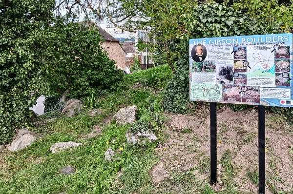
The Gibson Boulders (UfdG19) and information signboard in Saffron Walden – Photo: D. Davey 2026
Other Sites of Geological Interest
ASHDON. Ashdon Parish Church
Erratic cobbles can be seen in the fabric of the church. Geologist Sir John Smith Flett (1869-1947) is buried in the churchyard. His grey granite tombstone is in the shadow of All Saints’ church tower with the following epitaph “He richly enlarged man’s knowledge of the earth”.
AUDLEY END. Audley End House Septarian nodule (TL 5217 3831)
On display in the Stable Block is a fine, large septarian nodule (1.65 x 1.15 x 0.30 metres in size) cut in half to display the internal calcite-lined cracks or ‘septa’. This nodule was no doubt collected locally and was part of the natural history collection acquired by the fourth Lord Braybrooke in the 19th century. It was moved from its previous position on the Tea House Bridge in 2003 to deter vandalism.
CLAVERING. Clavering Swallow Hole (TL 4764 3175)
A swallow hole is a depression in the ground in a limestone or chalk area into which a stream disappears underground. This example currently takes the form of a two metre wide solution hole in the chalk bedrock of the river. It is the route by which water flows into the chalk aquifer. Discovered by the Environment Agency. It is choked with debris and usually not visible due to the growth of vegetation. Access to the stream bed is hazardous. View from the road only.
GREAT CHESTERFORD. Great Chesterford C of E Primary School (TL 5072 4282)
The main school building, built in 1849, consists of knapped flints, with limestone dressings on a gault brick plinth. A very fine example of flint architecture.
LANGLEY. Highest point in Essex (TL 4429 3619)
A point 1 kilometre north of Langley church is the highest point in Essex. It is 147 metres above sea level on the rolling chalk hills of north-west Essex. The Harcamlow Way, a long distance footpath, passes through this point.
SAFFRON WALDEN. Ashdon Road Swallow Hole (TL 561 391)
A swallow hole is a depression in the ground in a limestone or chalk area into which a stream disappears underground. Some swallow holes are not obvious on the surface and are merely a point where a stream appears to dry up as it percolates through its gravel bed to continue its journey underground. An example of the latter is in the valley of The Slade where, during most times of the year, the stream disappears underground as it flows from the boulder clay plateau onto the Chalk at a point adjacent to the public footpath midway between Martins Wood and the Ashdon Road.
SAFFRON WALDEN. Grave of Edward Charlesworth (TL 5469 3847)
In the town cemetery is the grave of Edward Charlesworth (1813-1893), an eminent but controversial Victorian geologist who coined the term Red Crag. It has a very fine gravestone with an excellent epitaph.
SAFFRON WALDEN. Ravine in the valley of The Slade
Remarkable natural ravine in the valley revealing chalky gravel that has yielded remains of mammoth and woolly rhinoceros.
SAFFRON WALDEN. Saffron Walden Museum Boulders (TL 5384 3872)
An interesting collection of erratic boulders in the grounds of the Museum, the most prominent being a very large and complete septarian nodule over two metres in diameter. There is also a fine basalt boulder (rare in Essex).
THAXTED. Stoney Lane (TL 611 309)
Stoney Lane, adjacent to the famous Guildhall, is a good example of a street paved with local erratics. The majority of the cobbles are flint but there are also a large number of other rock types.
TYE GREEN. Tye Green Kettle Hole (TL 538 238)
The public footpath from Tye Green to Warmans Farm passes around the rim of the north portal of the Stansted Airport railway tunnel. Prior to construction of the railway in 1989, trial boreholes along the proposed route of the tunnel revealed the presence of a deep depression in the boulder clay, which was filled with black organic sediments dating from the Hoxnian interglacial stage (400,000 years old). When the tunnel portal was constructed the sediments yielded interglacial fossils. This feature has been interpreted as a ‘kettle hole’ dating back to the time of the Anglian Ice Sheet some 450,000 years ago. Kettle holes are depressions created by the melting of blocks of stagnant ice left behind by the retreat of a glacier or ice sheet, in this case the Anglian Ice sheet that covered north Essex 450,000 years ago. Nothing now visible on the ground. Of historical interest only.
WICKEN BONHUNT. St. Helen’s Chapel (TL 5114 3349)
This small, thatched, 11th century chapel is one of the oldest buildings in Essex. Apart from the front wall, which is brick, the walls consist almost entirely of glacial erratic cobbles and boulders gathered from the local fields 1,000 years ago. A large variety of rock types are present (inside and out) including at least 16 pieces of Hertfordshire puddingstone. The north-eastern corner is supported by a large sarsen stone.