Southend-on-Sea
The following sites have been selected to represent the different aspects of geology and landscape in the district. Not all sites have something to see; many are solely of historical interest as a record of an important or interesting discovery.
Some sites are not strictly geological but have a geological connection. Geological sites are therefore defined in their widest sense and include, for example, buildings, walls, wells, spas, springs, graves, boreholes, plaques, landslips and viewpoints.
This is not a complete list of geological sites in the district. Others will be added and descriptions expanded as further research is carried out.
Important note:
Not all of the sites here described are accessible. Some sites are on private land and can only be viewed from footpaths that pass through or alongside the site. Inclusion of a site on this list does not, therefore, imply any right of access. Please remember not to trespass on private land.
Sites of Special Scientific Interest (SSSIs)
No geological SSSIs have been notified in the district.
Local Geological Sites (LoGS)
Click the links below to read and download the district report and LoGS citations for Southend City Council
Southend City Council – Report on Local Geological Sites – August 2025
SoG1 – St Laurence & All Saints Church, Eastwood
Between the pews and poking through the floorboards inside the Church is a sarsen stone 65 by 60 centimetres in size (approx. 2 foot by 2 foot). Sarsens are unusual hereabouts and are thought to come from the Medway gravels and therefore originating in Kent.
Other Sites of Geological Interest
For completeness, the following sites also contribute to the geodiversity of the district.
Eastwood Pumping Station (TQ 862 880)
In the nineteenth century the Southend Waterworks Company was formed to supply Southend with fresh water. One of these is the No. 3 well at Eastwood Pumping Station which was constructed between 1888 and 1890. The well is 871 feet (265 metres) deep, the first 247 feet (75 metres) beneath the well house floor is an 8 foot (2.5 metre) diameter shaft and below that it is bored. Old water company records provide information about the geology. Beneath 40 feet of terrace sand and gravel the well passes into London Clay (240 feet thick) below which is sand and clay of the Lower London Tertiaries (146 feet thick) and at the base the well penetrated 439 feet of Upper Chalk with its characteristic flints. Very little water was obtained from the Chalk but water from the Lower London Tertiaries rose up the shaft to within 66 feet of the surface.
Leigh Spring, Leigh-on-Sea (TQ 838 857)
In the High Street is a19th century brick structure at the bottom of a conduit carrying water from a cliff top spring. There is a cast iron plaque dated 1846. The spring no doubt issued from the junction of the Thames terrace gravels with the underlying London Clay. A stone in Rectory Grove, not now in its original position, was placed at the well head in 1712.
Leigh Cement Works – site of
In the early nineteenth century, before any of the modern sea defences were constructed along the northern shore of the Thames estuary, the cliffs of London Clay were subject to extensive coastal erosion. As a result, the hard septarian nodules that are contained in the London Clay accumulated on the foreshore in considerable quantities. In the past, particularly in the Roman period, these nodules were a useful source of building stone but in the early nineteenth century they were used for the manufacture of Roman cement which was very popular before the invention of Portland cement in 1850.
Friars Park, North Shoebury (TQ 938 861)
The former Shoebury brickfields produced spectacular fossils of Ice Age mammals. Fossils from Shoebury in Southend Museum include the bones of mammoth, elephant, bison, giant deer and brown bear. Much of this land is now occupied by housing and retail development but some abandoned pits are still visible as lakes. Some of these are in the wildlife reserve known as Friars Park. Of historical interest only.
Roots Hall Gravel Pit – site of
Southend United’s football ground was built in the 1950s on the site of a former gravel pit known as Roots Hall Pit. It was an ideal location as the long period of gravel extraction had led to a bowl-shaped site. The gravel, known as Southchurch Gravel, was originally deposited as a terrace of the northward- flowing Thames-Medway River during the middle of the Ice Age. In Southend Central Museum are two flint hand-axes and some flint flakes that came from this pit. The hand-axes were found in 1914 and 1935.
Shoeburyness Foreshore (TQ 920 840 approx.)
A foreshore platform of London Clay has sometimes been visible at low tide at various points between Southend and Shoeburyness. Until sea defences were built, fossils could be found here such as sharks’ teeth and fruits and seeds preserved in pyrite.
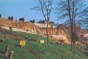
Southend Cliffs (TQ 875 851 approx.)
A classic area for demonstrating the problems of landslips in London Clay slopes. Movement of the ground along much of the Southend coastline is still a constant issue for the Council engineers, the most serious landslips occurring at The Cliffs, a section of coast just over a kilometre (approximately ¾ mile) long between the Cliffs Pavilion and Southend Pier. See also Hadleigh Castle (Castle Point District).
Thorpe Bay Brickworks – site of
In the late nineteenth and early twentieth centuries the present residential area of Thorpe Bay was the site of several brickworks. The largest of these included the site now occupied by Thorpedene Junior School (TQ 924 853) and shown on the 1923 Ordnance Survey map. The brick pits were exploiting the same large expanse of brickearth, or loess, that was being worked at North Shoebury (see separate site record) and similar fossils were most likely found. The public open space north of the railway at the junction of Maplin Way and Bishopsteignton (TQ 922 857) was also a brick pit.