Thurrock
The following sites have been selected to represent the different aspects of geology and landscape in the district. Not all sites have something to see; many are solely of historical interest as a record of an important or interesting discovery.
Some sites are not strictly geological but have a geological connection. Geological sites are therefore defined in their widest sense and include, for example, buildings, walls, wells, spas, springs, graves, boreholes, plaques, landslips and viewpoints.
This is not a complete list of geological sites in the district. Others will be added and descriptions expanded as further research is carried out.
Important note:
Not all of the sites here described are accessible. Some sites are on private land and can only be viewed from footpaths that pass through or alongside the site. Inclusion of a site on this list does not, therefore, imply any right of access. Please remember not to trespass on private land.
Sites of Special Scientific Interest (SSSIs)
A13 Road Cutting SSSI, Aveley (TQ 556 799)
During excavation for the A13 trunk road to the south of Aveley in 1997 a sequence of Ice Age sediments were found that were equivalent to those that contained the fossil elephants at Sandy Lane Pit directly to the north. Excavations for the cutting beneath the Purfleet Road bridge provided a revealed a cold-climate gravel at the base overlain by fossiliferous sands and clays (known as the Aveley Silts and Sands). The upper part of the interglacial sequence was represented by two layers of clay rich in vertebrates, molluscs, insects, plant remains and pollen indicating that the climate was at least as warm as the present day. The whole sequence is capped by sand and gravel indicating a return of very cold conditions. The interglacial represented here is the same as that represented at Sandy Lane Pit and therefore about 200,000 years old (in recognition of this site this interglacial stage is often called the ‘Aveley Interglacial’). Bones of a range of mammals were found such as brown bear, wolf, giant deer, mammoth, straight-tusked elephant, rhinoceros, horse, bison and a very large lion. Of particular interest was the first discovery in Britain of the bones of a ‘jungle cat’. Although grassed over, the road cutting can be seen from the Purfleet Road bridge.
Lion Pit Tramway Cutting SSSI (part of Chafford Gorges Nature Park), Chafford Hundred (TQ 598 781)
This site, part of an old tramway cutting created in the nineteenth century to transport chalk from Lion Pit to the riverside wharves, provided an excellent section through Ice Age sediments which are banked up against an ancient riverside chalk cliff that existed here about 200,000 years ago. These river deposits span a period of deposition from one glacial stage through to the next which includes the intervening interglacial stage, at the beginning of which there were early humans here, making stone tools on the gravel beach below the cliff. Evidence of human occupation has been flint knapping debris in the lower gravel which is undisturbed. Remarkably it has actually been possible to refit some flakes together, which proves that humans were actually manufacturing stone tools here. The humans occupying the site were Neanderthals. The tramway cutting has also produced the fossil bones of several species of mammals such as brown bear, rhinoceros, bison, mammoth and straight-tusked elephant. The sides of the cutting are now grassed over.
Globe Pit SSSI, Grays (TQ 625 783)
Globe Pit in Whitehall Lane is of geological importance because of the occurrence, on the eastern side of the pit, of Corbets Tey Lower Gravel containing abundant Palaeolithic flint tools, above which is a brickearth that was formerly very fossiliferous. The gravel and the brickearth were deposited by the River Thames when it flowed through here about 350,000 years ago. These Thames deposits sit on top of the Thanet Sand, which in turn lies on top of the Chalk which is exposed on the floor of the quarry. The flint tools in the gravel are known as ‘Clactonian’ and represent an industry that was first recognised in the cliffs at Clacton and that is based on flint flakes and cores rather than hand-axes. Globe Pit is also important because the brickearth is virtually all that remains of the celebrated ‘Grays brickearth’, a fine grained silt containing fossil shells which was a rich source of spectacular Ice Age fossil mammals. Surviving remnants of this deposit are valuable as no modern studies of its small vertebrate fossils has ever been carried out, studies which could yield much information about the fauna and climate of this little understood period of the Ice Age. There is no access to the site for casual visitors but visits are sometimes arranged for organised groups.
Purfleet Chalk Pits SSSI (Greenlands Quarry), Purfleet (TQ 569 786)
Greenlands Quarry at Purfleet (sometimes called Dolphin Pit) is of critical importance for interpreting the sequence of events in the Lower Thames valley during the middle of the Ice Age. Here, sediments are banked up against the northern side of the Purfleet anticline, an east-west ridge formed by a fold in the Chalk strata, and contain a record of three separate periods of early human occupation that makes this site unique in Britain. The first is a cold climate gravel at the base followed by warm climate sediments and capped by gravel representing a return to cold or glacial conditions. Based on the fossils and other evidence geologists have concluded that the warm climate sediments were laid down by the Thames during an as yet unnamed interglacial stage (provisionally called the ‘Purfleet Interglacial’ after this site) that is thought to be over 280,000 years old. Fossils found include the bones of deer, bison, monkey, beaver and straight-tusked elephant, and a single 3 centimetre diameter coprolite (fossilised faeces) of a hyena. Three adjacent disused quarries (Bluelands Quarry, Botany Pit and Esso Pit) also form part of the Purfleet Chalk Pits SSSI. For safety and security reasons the Greenlands Quarry section is not accessible to the public and is only accessed via a locked gate in Armor Road. Visits, however, are periodically arranged for organised groups.
Local Geological Sites (LoGS)
Click the links below to read and download the district report and LoGS citations for Thurrock Council.
Thurrock Council – Report on Local Geological Sites – December 2020
ThG1 – Arena Essex Sand Pit, West Thurrock
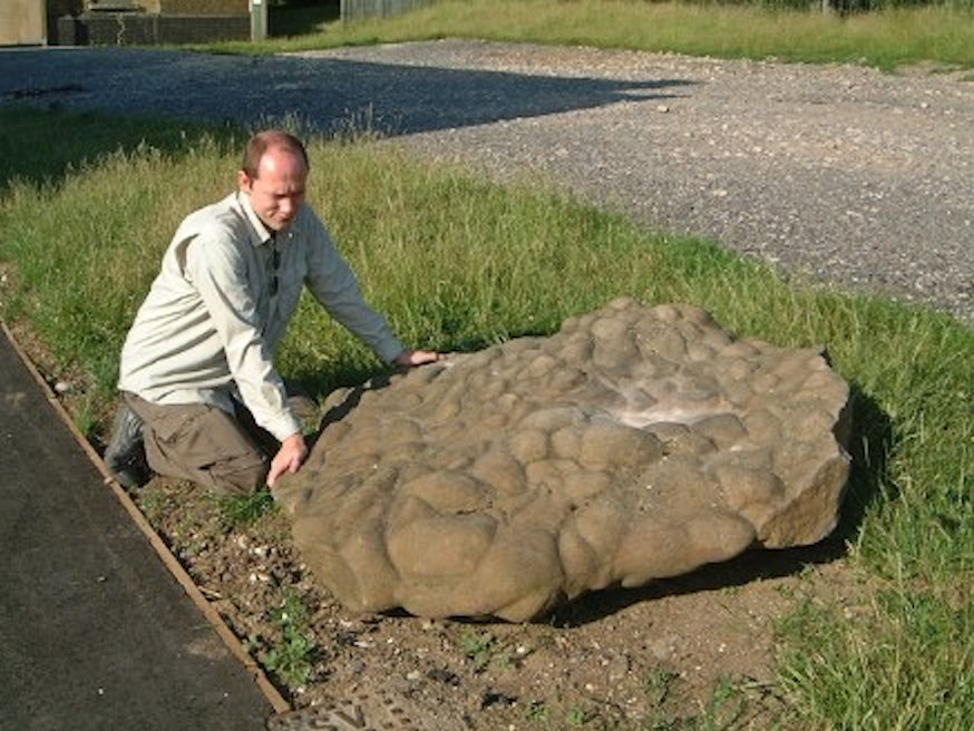
On the south side of the A13, in a large sand pit that was formerly the Arena Essex Motor Sports Complex, is a fine collection of at least 20 large sarsen stones with exceptionally well-preserved surface structures. The largest stone is over three metres long and is almost certainly the largest sarsen in south Essex. Most of the stones were piled up in one place close to the car park at TQ 5875 7967 but others were scattered about. One stone was sticking out of a bank of what appears to be Thanet Sand. This may be a unique in-situ example.
ThG2 – Belhus Woods Country Park, Aveley
Straddling the border between Thurrock and the London Borough of Havering, Belhus Woods Country Park contains many lakes that were originally gravel pits. The area is situated on the Lynch Hill terrace of the Thames, which contains Corbets Tey Gravel, deposited by the river about 300,000 years ago. The old gravel workings, formerly known as Hunts Hill Farm and Whitehall Wood Pits, have fortunately been spared ‘landscaping’; therefore most of the pits still retain their original profiles with some gravel and sand still visible in the banks.
ThG3 – Bluelands Quarry (N & E faces), Purfleet
The south and west faces of Bluelands Quarry are part of the Purfleet Chalk Pits SSSI (see above). The north and east faces are not included in the SSSI and so are proposed as a Local Geological Site. Bluelands Quarry is currently (2020) being infilled and the gravels, sands and clays overlying the Chalk are becoming accessible as the infilling proceeds. The sediments overlying the Chalk were laid down by a former course of the Thames about 300,000 years ago and are part of the Corbets Tey Formation. The central part of the sequence was deposited during an interglacial period informally known as the ‘Purfleet’ Interglacial, after these sites.
ThG4 – Brickbarn Wood, South Ockendon
One of the finest collections of sarsen stones in the country is situated in Brickbarn Wood and the adjacent Combe Wood on the south side of the Mardyke Valley adjacent to the cutting of the A13 trunk road. It is estimated that as many as 40 stones may be present, most of them partially buried in soil from old gravel pits. Many of the stones are over 2 metres long and have fine mammilated surfaces. Private woodland. Access is available with permission of the landowner. The two woods are a local Wildlife Site.
ThG5 – Buckingham Hill Sand Quarry (Tarmac Pit), Orsett
The disused Buckingham Hill Pit, north-west of Walton’s Hall, was formerly operated by Tarmac and is often referred to as the Orsett Tarmac Pit. It provides very fine exposures of the Woolwich Beds sands. Of particular interest is the preservation in the cliff faces of burrows of crustaceans that lived on the sandy sea floor some 55 million years ago. The cliff face profiles should be retained in any future development scheme.
ThG6 – Davy Down Sarsen Stone, South Ockendon
Davy Down Riverside Park forms part of the Mar Dyke Valley, a delightful valley with steep, wooded sides and a grazed floor that can be seen from the M25 motorway. The valley runs along the northern side of the Purfleet Anticline, an east-west trending ridge of chalk between Purfleet and Grays. Also of interest at Davy Down is the pumping station, built in 1928 with a 50 metre deep borehole down into the Chalk. It is still used today for pumping water for use in the local area. Outside the pumping station is a remarkable sarsen stone – probably the finest example in Essex. The sarsen is 1.6 metres square and has fine mammillated surfaces. It formerly stood outside Marley’s works on the south side of Stifford Road, South Ockendon and is understood to have been found in the gravel pit south of the works.
ThG7- Gravelhill Wood (part of Langdon Hills Country Park)
The Langdon Hills consist of London Clay overlain by Claygate Beds with Bagshot Sand capping the highest ground. This in turn is capped by Stanmore Gravel (formerly called ‘pebble gravel’), the origin of which is still not fully understood but may have been laid down by northward-flowing south bank tributaries of the pre-diversion Thames up to a million years ago. Gravelhill Wood, south-west of the church, contains at least two large gravel pits, very overgrown, but with plenty of gravel visible here and there, especially where trees have toppled over or badgers have been at work. There are fine views from the highest ground here over the Thames Estuary, although some viewpoints have been lost due to uncontrolled tree growth. The Country Park is run by Thurrock Council’s Ranger Service.
ThG8- Chafford Gorges Nature Park, Chafford Hundred
Chafford Gorges Nature Park is the finest area for geology in south Essex. Spectacular cliffs of Upper Chalk can be seen which are a legacy of quarrying for the Portland Cement industry. The Chalk is overlain by Thanet Sand and gravels from former routes of the Thames during the Ice Age. There are also several fine sarsen stones around the rim of Grays Gorge. The park consists of seven geological sites (Grays Gorge, Lion Gorge, Lion Pit Tramway Cutting SSSI, Millwood Sand Cliff, Sandmartin Cliff, Warren Gorge and Wouldham Cliff), which are under the control of Essex Wildlife Trust. Lion Pit Tramway Cutting SSSI is one of the most important of the County’s SSSIs, yielding evidence of human occupation on the banks of the Thames 200,000 years ago. The visitor centre has fine views overlooking Warren Gorge. A geological trail guide is available.
ThG9 – Gun Hill Gravel Pit (Broom Hill), West Tilbury
The ridge of high ground between West Tilbury and Chadwell St. Mary is a high terrace of the present Thames and to the south the land falls steeply down to the Tilbury Marshes. On this ridge, at the high point known as Gun Hill (also known as Broom Hill) is a private disused gravel pit with exposures of Orsett Heath Gravel, the oldest and highest of the Thames terraces. The layers of sand and gravel were laid down by the River Thames some 380,000 years ago in the middle of the Ice Age. The gravel is now some 25 metres above the level of the present Thames, an excellent example of the erosion that has taken place over this period of time. This is demonstrated by the fine view that can be had from here across the Tilbury Marshes to the modern river. The site is, in effect, a fossil cliff line and is well placed to explain the loop of the Thames around Tilbury.
ThG10 – Kennington Park, Aveley
Kennington Park was created from gravel pits alongside the Romford Road and the former pits are now publicly accessible fishing lakes. When the park was created there were several exposures of gravel, particularly alongside the path on the northern edge of the park where it formed low cliffs up to 2 metres high. The best of these exposures is unfortunately now contained within a members only fishing area known as Back Lake. The gravel is Orsett Heath Gravel which forms the oldest and highest terrace of the Lower Thames and about 400,000 years old.
ThG11 – One Tree Hill Brick Pit (part of Langdon Hills Country Park)
One Tree Hill is one of the high points of the Langdon Hills. The hill is capped with Claygate Beds and an isolated patch (an outlier) of Bagshot Sand on the very highest ground. The pit was worked by the former Corringham Brick and Tile Company. The pit still exists in a fenced off area although it is much overgrown. The Bagshot Sand is sometimes visible in heaps thrown out from animal burrows. It would be possible to create a section in one of the steep banks. The Country Park is run by Thurrock Council’s Ranger Service.
ThG12 – Orsett Cock Quarry (Southfields Quarry), Orsett
The quarry is situated behind the old Orsett Cock public house and once provided a magnificent exposure of the basal part of the Woolwich Bottom Bed (the Upnor Formation). It consists mostly of extremely well-rounded pebbles representing a cross section through an ancient sea floor some 55 million years ago. The pebbles are black and many have crescent-shaped percussion or ‘chatter-marks’, indicating that they have been pounded together on a beach in a high-energy environment. This bank of pebbles was an impressive sight, forming a vertical cliff. It was the best inland exposure of this particular formation.
ThG13 – Purfleet Submerged Forest, Purfleet
Part of a submerged forest, between 5,000 and 6,000 years old, consisting of fallen tree trunks and roots, is exposed on the Thames foreshore. This site and other submerged forests along the Thames (e.g. at Rainham nearby) have been studied since 1665. This site has educational importance in the interpretation of sea level changes since the end of glacial conditions some 10,000 years ago. The forest can be seen only at low tide.
ThG14 – Sandy Lane Pit (site of), Aveley
To the west of Kennington Park is the famous Sandy Lane Clay Pit where, in 1964, the remains of a mammoth and a juvenile straight-tusked elephant were discovered in Ice Age deposits channelled into the London Clay. The discovery received considerable publicity in the national press. The fossils are now in the Natural History Museum, London. Attempts to conserve part of the Sandy Lane Pit (also known as Aveley No. 2 pit) as a Site of Special Scientific Interest (SSSI) unfortunately failed as planning consent for landfill had already been granted. The pit has therefore now been infilled. However there may be some undug land on the edges of the pit that could provide scope for future investigation (Bridgland et al. 2003). An interpretation board could be provided in the vicinity about the Aveley elephants, perhaps in the car park of Kennington Park nearby.
ThG15 – Stanford Warren Sarsen Stone, Mucking
To the east of the former church a very large sarsen stone at about 2.2 x 1.3 x 0.6 metres in size, with a mammilated surface, is sitting by the path at the entrance to Stanford Warren Nature Reserve (Essex Wildlife Trust). The boulder was rescued from the large Mucking Gravel Quarry nearby which was landfilled in 2007.
ThG16 – Turners Farm Gravel Pit, Mucking
A disused gravel pit on private land next to Turners Farm on Walton’s Hall Road (opposite Walton’s Hall Museum) has a fine section through the Mucking Gravel, representing the bed of the Thames some 200,000 years ago. The east face of the pit is about 5 metres high and provides one of the best vertical sections through Thames Terrace gravel to be seen in the Thames Valley.
Other Sites of Geological Interest
For completeness, the following sites also contribute to the geodiversity of the district.
Chadwell St. Mary sarsen stone (TQ 646 785)
In the churchyard is a sarsen stone (1 x 0.5 x 0.35 metres in size) with mammillated upper and lower surfaces.
The Fobbing borehole (TQ 7127 8435)
The Fobbing Auxiliary Well, north-west of Fobbing church, was sunk in 1904 by the Southend Waterworks Company and terminated in the Upper Chalk at a depth of 551 feet. However, what made this well of great geological interest was the water company’s decision two decades later, in 1924, to deepen it by sinking a borehole at the bottom which more than doubled its depth taking it right down to the ancient Palaeozoic basement rocks. Deepening the well must have been a success for the water company. At the base of the Lower Greensand water rushed in and rose to a height estimated at the time to be 83 feet above sea level. As the well house floor was only 65 feet above sea level this well must have been an ‘artesian’ well which means that water fills the entire well or borehole and overflows at the surface. Today the borehole has a cast iron cover and is situated on land still in use by the water company but there is no public right of way to the site. A drawing of the borehole with descriptions of the strata is held by GeoEssex (produced by the water company in 1966 at a scale of 24 feet to one inch).
Hangmans Wood Deneholes, Grays (TQ 631 794)
Hangman’s Wood contains the most extensive a best preserved set of deneholes in existence. Deneholes are thought to be medieval chalk mines and consist of vertical shafts through the Thanet Sand and end in branching chambers cut into the underlying chalk. The Hangman’s Wood deneholes are particularly deep, the shafts being over 20 metres deep before the Chalk is reached. There are up to 70 deneholes here but almost all are infilled. Those that are open are fenced. The site is a biological SSSI for the bat colony.
The Dell, Grays
Former home of Alfred Russel Wallace (1823-1913), zoologist, botanist, geologist and anthropologist, was one of the greatest scientific minds in Victorian Britain. He is most well known as the co-discoverer, with Charles Darwin, of the laws of evolution by natural selection. Wallace built the house and lived here from 1872 to 1876. The house is still in existence at the very end of College Avenue and is part of the adjacent convent school. It is provided with a heritage plaque to commemorate its famous former resident.
Thurrock Museum Sarsen Stone, Grays (TQ 6153 7814)
The report of a visit by the Geologists’ Association to Globe Pit in Whitehall lane in September 1959 records the finding of a large sarsen stone, described as ‘six feet long and four feet wide’ at the southern end of the pit. This stone, which is a fine example of a sarsen stone, is now in the grounds of the library and museum in Orsett Road. It was originally proposed to be positioned in the garden at the front of the Museum but this never happened. Thurrock Museum contains a number of interesting fossils from the local neighbourhood including the Boatman collection, a small but historically important Victorian fossil collection which was donated to the museum in 1964. Boatman was a jeweller and watchmaker in the old Grays High Street, south of the present railway crossing.
Thurrock College Sarsen Stone, Grays (TQ 635 788) (current whereabouts unknown)
A fine sarsen stone (1.3 x 1.1 metres in size) was formerly standing upright on the grass in front of Thurrock College in Woodview. Before that, it was lying flat on the paving by the college entrance (see photograph). According to a former lecturer at the college the stone was found during nearby road construction work in the late 1960s. The stone has fine mammillated surfaces on both sides. Thurrock College has now been demolished and replaced with a housing estate. Unfortunately, the stone has been moved by the contractors and its current whereabouts is unknown. This is unfortunate as it would have made a fine monument of scientific interest standing upright at the entrance to the housing estate.
Grays Town Park, Grays (TQ 618 781)
The town of Grays developed around the brick-making industry which was once of great economic importance to the area and produced spectacular fossils of Ice Age mammals such as mammoth and straight-tusked elephant, lion, brown bear, hyena, rhinoceros, monkey, bison, and beaver. The undulating ground in various parts of Grays is the only evidence today of this industry. The sunken ground of Grays Park, a disused brick pit purchased by Grays Town Council in 1898, is a good example of this.
Rainbow Shaw Quarry, Linford (TQ 665 801)
Rainbow Shaw Quarry on Holford Road, north-west of Linford, is currently an active quarry working Thanet Sand. Lying on top of the Thanet Sand is Orsett Heath Gravel.
Stanford Warren Angling Lakes, Mucking (TQ 689 815)
The type section of the Mucking Gravel, representing the bed of the Thames some 200,000 years ago, is situated on private land used as angling lakes adjacent to Essex Wildlife Trust’s Stanford Warren Nature Reserve. The former gravel pit is now Stanford Warren Angling Lakes, which are an important fishery and habitat for birds. Public access to the lakes is restricted to the car park but views can be obtained when following the short circular walk. Close to the edge of the site is a fine, though small, exposure of gravel.
Vange Mineral Well, Langdon Hills (TQ 7002 8627)
In the parish of Fobbing, not far from the Five Bells interchange at Vange, are the remains of a curious domed structure, which originally resembled a temple. Although the building was originally built on open land, it is now situated in Martinhole Wood, which is part of the One Tree Hill Section of Langdon Hills Country Park. Known as Vange Mineral Well No. 5, it is now sadly a ruin but in the early twentieth century it was the centre of a widely publicised mineral water business. The site is on the slopes of One Tree Hill and the water originated from the junction between the sandy Claygate Beds and the impervious London Clay below. The building is in danger of collapse and requires urgent repairs.
North Stifford Church Puddingstone. (TQ 6044 8031)
St. Mary’s Church contains a remarkable variety of local stone types, particularly the boulder (0.75 x 0.6 metres) supporting the north-west corner. The boulder consists of layers of black-coated flint pebbles set in a sarsen matrix. Similar to ‘Hertfordshire puddingstone’, this boulder is unique in south Essex.
Dansand Quarry, Orsett (TQ 651 810)
The Dansand Quarry on the Stanford Road (west of Brentwood Road) currently provides exposures of the sands of the Woolwich Beds. They take the form of very steep to almost vertical cliffs on the northern faces which mark the edges of the original quarry. The Woolwich Beds sands are capped by Orsett Heath Gravel in places. These cliffs could be easily retained in any future use of the site.
Purfleet foreshore Chalk outcrop, Purfleet (TQ 54931 78340)
A small outcrop of Upper Chalk can be seen at low tide on the foreshore at Purfleet just a few hundred metres north-west of the Royal Hotel. This is the oldest rock exposed on the Essex coast. The Chalk contains numerous flints and occasional fossils. Additionally, at very low Spring tides, the feather edge of a Neolithic Submerged forest can be seen resting on the underlying Chalk (see also Purfleet Submerged Forest LoGS).
The Dipping (Church Hollow), Purfleet (TQ 551784)
Former chalk quarry on the south-west slope of Beacon Hill with fine vertical chalk face on its northern boundary. Much of the quarry floor is occupied by residential development. The quarry was also called Tank Lane Quarry. Church Hollow is the name of the western part of the site originally occupied by a chapel, school and schoolmaster’s house built by the Whitbread family (owners of the quarries) for its estate workers. Chalk was quarried here from as early as the 16th century and therefore this quarry is of great historical as the site of the earliest commercial chalk workings in Thurrock.
St Nicholas Church, South Ockendon (TQ 5949 8290)
An example of an unusual building style with a geological connection. The construction of round church towers came about because of the difficulty of making satisfactory corners with natural unknapped flints. There are six round tower churches in Essex and this is one of the best examples.
Dolphin Chalk Quarry, West Thurrock (TQ 571 780)
Formerly known as the Metropolitan Works Quarry, the Dolphin Chalk Quarry is situated between Stonehouse Lane and Canterbury Way (the Dartford Tunnel approach road) and contains a cement manufacturing plant and an industrial estate. The 20 metre high vertical chalk face that forms the western side of the quarry is the most remarkable chalk cliff in Essex as it shows regularly spaced bands of flint nodules which represent cycles of climate change (Milankovitch climate cycles) during the Cretaceous period some 80 million years ago. These flint bands are better displayed here than anywhere else in Essex and, due to aspect and differential weathering, are not even clearly visible in the adjoining quarry.
Lakeside (Tunnel Cement Works Quarry), West Thurrock (TQ 585 780)
Lakeside Shopping Centre occupies the floor of the former giant Tunnel Cement Works chalk quarry. In 1968 the Tunnel Cement Works was the largest in Western Europe with 1,200 employees. Steep and vertical faces of chalk are still visible today around the edges of the old quarry with clear bands of flint nodules. However, several faces are covered in geotextiles to prevent falling rock and most are fenced off or otherwise inaccessible. Currently the best and most accessible chalk face is on the south side, off Motherwell Way (behind IKEA). Access is best through the Cliffside Trading Park, open to the public during office hours, where the face can be seen between Units 6 & 7 (TQ 585 780).
Tesco Distribution Centre Quarry, West Thurrock (TQ 570 781)
Tesco’s distribution centre occupies the southern part of Greenlands Quarry and is accessed from Dolphin Quarry via Dolphin Way through a tunnel under the A1090 (Stonehouse Lane). Fine chalk cliffs encircle the building but the cliff on the north side is of particular interest as the top third is coombe rock, a shattered chalk which is direct evidence of an extremely cold climate in Thurrock during the last glacial period, about 15,000 years ago.
Low Street Pit, West Tilbury (TQ 672 775)
A disused, wooded sand and gravel pit south of Station Road between east Tilbury and West Tilbury. It is situated on a patch of Mucking Gravel, which is the down-stream equivalent of the Taplow terrace of the Thames and was laid down about 200,000 years ago. The gravel has been excavated down to the Thanet Sand below which is exposed on the floor of the pit. The pit has been designated as a Local Wildlife Site.
West Tilbury Hall Well (TQ 660 777)
The 16th century West Tilbury Hall and former church sit near the summit of a steep-sided, gravel-topped hill. In the early 18th century there was discovered here a medicinal spring or well which afterwards became famous – more so than any other Essex well. It retained its fame, too, for a long period and appears to have been the only Essex medicinal water to have enduring commercial value. The well was first sunk in 1724 and its medicinal value was discovered some three years later. The fame of Tilbury Water increased throughout the 18th century and was advertised extensively in London newspapers. It was promoted by prominent doctors and physicians at the time including Sir Hans Sloane, who was “so well convinced of the great efficacy of the Tilbury water that he frequently recommended it to his patients”. Despite refurbishment at West Tilbury Hall, the original well has not been rediscovered. Thurrock Museum, however, has in its collection one of the original two pint glass bottles stamped with the words ‘West Tilbury Hall’. The water from the wells owes its chemical composition to filtering through Thames gravel (Orsett Heath Gravel) and Thanet Sand, which caps the hill at West Tilbury.