Chelmsford
The following sites have been selected to represent the different aspects of geology and landscape in the district. Not all sites have something to see; many are solely of historical interest as a record of an important or interesting discovery.
Some sites are not strictly geological but have a geological connection. Geological sites are therefore defined in their widest sense and include, for example, buildings, walls, wells, spas, springs, graves, boreholes, plaques, landslips and viewpoints.
This is not a complete list of geological sites in the district. Others will be added and descriptions expanded as further research is carried out.
Important note:
Not all of the sites here described are accessible. Some sites are on private land and can only be viewed from footpaths that pass through or alongside the site. Inclusion of a site on this list does not, therefore, imply any right of access. Please remember not to trespass on private land.
Sites of Special Scientific Interest (SSSIs)
River Ter SSSI, Great Leighs (TL 744 155 to TL 733 157)
The stretch of the River Ter in the vicinity of Lyons Hall has been notified as a geological SSSI because it is representative of a lowland stream with a distinctive flood regime. It illustrates well the relationship between river discharge and channel dimensions and has been used to test theories about why rivers adopt a meandering course. There are public footpaths alongside the river (including the Essex Way).
Newney Green Pit SSSI (TL 648 065)
Kesgrave (Thames) Sands and Gravels are present at this site with a palaeosol (fossil soil horizon) of pre-Anglian age. This is overlain by boulder clay (till) which was deposited by the Anglian Ice Sheet. Occasional patches of glacial gravel are also found, and an (Anglian) arctic structure soil is superimposed on the pre-Anglian palaeosol marking a change from warm interglacial to intensely cold glacial conditions. This site is of prime importance for the correlation between Pleistocene sites in the Thames and East Anglian areas. A vital locality in working out the sequence of events in the evolution of the Thames. The pit has now been infilled except for the small area of the SSSI. The site is on private land.
Local Geological Sites (LoGS)
Click the links below to read and download the district report and LoGS citations for Chelmsford City Council.
Chelmsford City Council – Report on Local Geological Sites – November 2024
ChG1 – Beehive Lane Sarsen Stone, Great Baddow
A sarsen stone 90 x 70 x 60 cm sits in the car park of the Beehive Public House in Beehive Lane. It was obtained from the old ‘Beehive’ gravel quarry before 1906.
ChG2 – Buell Spring, Danbury
Spring issuing clear water from a cast iron pipe. Remains of pumping station. Spring originates from the spring line that runs right around Danbury Hill (from between the Danbury Gravel and the London Clay). Historically important as the water supply for the area. Of particular interest is the accumulation of ‘bog-iron’ nearby – a cementing of the soil by the iron compounds leached out of the gravel. Land owned by the National Trust.
ChG3 – Channels Boulders, Little Waltham
By the entrance to Channels is a large boulder of puddingstone on a mound of grass by the roadside. It is one of the largest puddingstone boulders in Essex, measuring 2.1 metres long by 1.2 metres high by 0.4 metres in thickness. Other puddingstones and sarsen boulders are nearby, one puddingstone with a signboard. These boulders were found in the local gravel pit, now the site of housing development.
ChG4 – Danbury Common Gravel Pits
Deep and extensive disused and overgrown gravel pits on east and west sides of Danbury Common (two separate patches of gravel) which provide visible sections through the Danbury Gravels – gravel that accumulated on the ice margin, where its southward progress was prevented by the London Clay high ground. Owned by the National Trust. Eastern pits heavily used by mountain bikers. The higher parts of the western pits are very sandy and used by badgers.
ChG5 – Fultons Farmhouse Boulder, Bicknacre
Basalt boulder, 90cm x 60cm x 35cm. Large erratic boulders of basalt are very rare in Essex, and this boulder was probably transported from the north by the Anglian ice sheet about 450,000 years ago. Bicknacre is close to the southern limit of the ice sheet.
ChG6 – Parsons Spring Pits, Highwood
Parsons Spring (also known as Parsons Wood) has numerous shallow but steep-sided pits where sand and gravel was once exploited. This sand and gravel is referred to on geological maps as ‘Stanmore Gravel’ (formerly called ‘pebble gravel’). How it was formed has been debated by geologists since the 19th century. Its origin is still unclear today although one theory is that it was laid down by a river, probably over one million years ago, during the early part of the Ice Age. The pits are clearly visible as overgrown hollows either side of footpath that runs through the wood.
ChG7 – Running Well, Runwell
An ancient spring that gave its name to the village. Situated 300 metres south-east of Poplars Farm between Runwell and Rettendon, the well still exists and the water is said today to be of good quality. First recorded in Morant’s History and Antiquities of Essex in 1768. The water flows from the junction between the Bagshot Sand and the Claygate Beds.
ChG8 – Russell Green Gravel Pit, Boreham
Former gravel quarry providing exposures of Kesgrave Sands and Gravels There is currently a fine vertical cliff of gravel on the west side of the lake, visible from the road. The site is privately owned with no public access.
ChG9 – Sandon Gravel Pit
The disused Sandon gravel pit has good exposures in Kesgrave Sands and Gravels. Much of the pit has not been restored and therefore the quarry slopes and edges are largely as they were when quarrying ceased. This makes the site important for geology as there are several small exposures of gravel, for example on the southern lake edge. The Kesgrave Sands and Gravels were laid down during the early Ice Age by the River Thames when it flowed through mid Essex and Suffolk. The gravel is mostly flint but also contains ‘exotic’ pebbles of rocks from far upstream. Sandon Pit is also a Local Wildlife Site.
ChG10 – Scrubs Wood Nature Reserve, Danbury
This site may have been a former gravel pit as the steep banks have plenty of gravel visible. The Danbury Gravel clearly dates from the Ice Age but its precise origin is still not clear, despite various investigations over the last 150 years. In 2017 the exposed gravel at Scrubs Wood contained abundant vein quartz and bunter quartzite pebbles. A ventifact (a wind-faceted stone) has been reported from here. Scrubs Wood is part of a biological SSSI known as Woodham Walter Common.
ChG11- South Woodham Ferrers Foreshore
River erosion at several places around the Essex coast has exposed evidence of human occupation dating from the Mesolithic Period. These settlements are now below high tide level and the most important of these is at Hullbridge/South Woodham Ferrers where a prehistoric land surface, possibly as much as 7,000 years old, is exposed on the foreshore of the River Crouch. The sites can only be examined at low tide.
ChG12 – Stock Road Gravel Pits, Stock
In woodland just west of the Stock Road, north of the village of Stock, are disused gravel pits. These pits are an important geological site because it was one of the very few places where the ‘Bagshot Pebble Bed’ was formerly exposed. The pits are now overgrown but with the permission of the landowner it would be relatively easy to re-expose the gravel for study.
ChG13 – Channels Till Cliff, Little Waltham
A section through the Anglian till (boulder clay) in the edge of the old quarry has been preserved. It is all that remains of a cliff of till that was the edge of the former Mid Essex Gravel Pit. This cliff forms the only accessible and visible exposure of glacial till in the whole of Essex. An access footpath and a signboard have been created at the site. There is also a large puddingstone at the site.
ChG14 – Chelmsford City Museum Puddingstone
Boulder of Hertfordshire puddingstone 70 x 60 x 30 cm by the front entrance to Chelmsford and Essex Museum in Oaklands Park.
ChG15 – The Channels Mammoth, Little Waltham
This sculpture depicting a Steppe Mammoth encapsulates the essence of the Ice Age deposits exploited by the former gravel pits around which the Channels housing development is sited.
ChG16 – Bushy Hill, South Woodham Ferrers
Bushy Hill to the north of the town is a prominent and locally important landscape feature. It is composed of London Clay capped by Claygate Beds with notable landslips on the southern and western slopes. There are fine views of the Crouch valley from the summit.
Other Sites of Geological Interest
Broomfield Sarsen Stones (TL 705 104)
Two small but conspicuous sarsen stones by the church gate, the largest 60 cm long.
Chelmsford Cathedral (TL 708 069)
Remarkable abundance of ‘bunter’ quartzite and Hertfordshire puddingstone from the Thames gravels in the extension to the chancel, built in 1923, and the vestry block, built three years later. Plus fine flint craftsmanship on the porch.
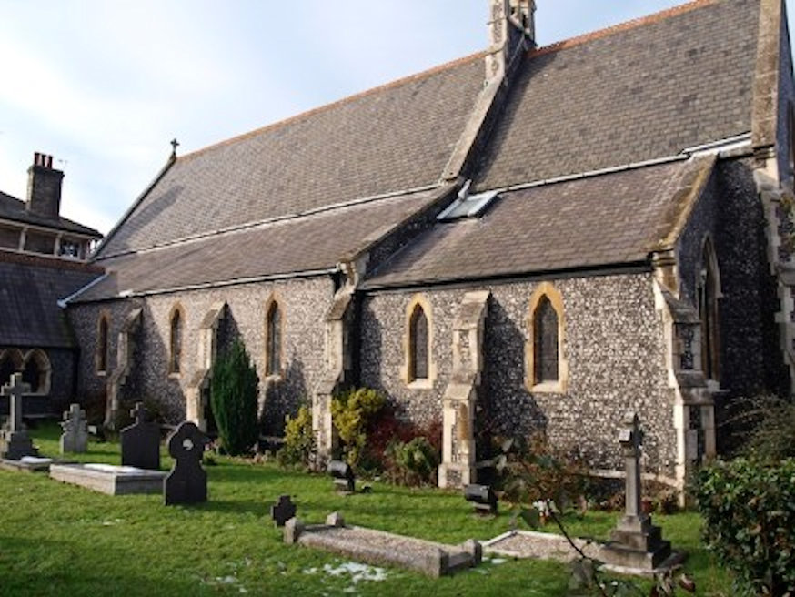
Church of Our Lady Immaculate, Chelmsford (TL 7050 0625)
Built in 1846 the Church of Our Lady Immaculate in New London Road is a fine example of the use of knapped flint. The flint walls have limestone dressings and the building has a roof of Welsh slate.
Former Moulsham Brickpits, Chelmsford (TL 702 060)
Large areas of old Moulsham were formerly brick pits and several of these produced Ice Age fossils in the 19th Century. Particularly notable were the bones of elephant and hippopotamus, some of which are on display in Chelmsford Museum. The conspicuous areas of low-lying ground on the north side of New London Road are former pits. In the latter part of the Ice Age hippos are only recorded as being present in Britain once, during the Ipswichian Interglacial period. These fossils are therefore considered to be Ipswichian in age (about 120,000 years old).
Pleshey Boulders (TL 648 143)
On the traffic island at a road junction west of the village is a splendid erratic boulder of Carboniferous Limestone 1.1 metre long with fossil corals and a sarsen stone 0.7 metre long.
All Saints Church, Rettendon (TL 770 960)
Typical church of Kentish Ragstone with a fine view. Splendid tomb of Italian marble.